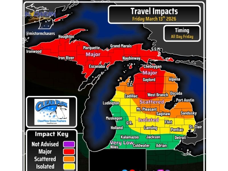
Michigan Winter Storm Threat: Heavy Snow and Powerful Winds Could Trigger Near-Blizzard Travel Conditions Friday
MICHIGAN — A strengthening winter storm is expected to bring widespread travel disruptions across much of Michigan on Friday, as moderate to heavy snowfall combines with powerful wind gusts to create dangerous road conditions. Forecasters warn that reduced visibility, blowing snow, and periods of near-blizzard conditions could make travel extremely challenging across large portions of the state.
The system is expected to impact both the Upper Peninsula and northern Lower Peninsula throughout the day Friday, with the most severe conditions likely in northern counties where heavy snow and strong winds are forecast to intensify.
Northern Michigan Faces the Most Severe Travel Conditions
Weather forecasts indicate the worst impacts will occur across northern Michigan, including areas near Marquette, Houghton, Iron River, Escanaba, and Grand Marais in the Upper Peninsula. These regions are expected to experience the most severe snowfall and wind conditions during the storm.
Maps outlining expected impacts show large portions of the Upper Peninsula in the highest impact category, where travel is strongly discouraged. Heavy snow falling alongside strong winds could quickly reduce visibility and create dangerous whiteout conditions across exposed highways and rural roads. Communities along Lake Superior and Lake Michigan may also see drifting snow as gusty winds push snow across roadways and open areas.
Northern Lower Peninsula Also Under Major Impact Risk
The storm’s reach will extend into northern portions of Michigan’s Lower Peninsula as well. Cities including Gaylord, Cheboygan, Alpena, and West Branch are expected to face major travel disruptions during the height of the storm.
Heavy snowfall combined with wind gusts could significantly reduce visibility for drivers, particularly during periods of intense snowfall. Forecasters say conditions could deteriorate quickly, especially in areas where blowing snow accumulates along roadways. Drivers traveling across northern Michigan Friday may encounter rapidly changing conditions as snow bands shift across the region.
Central Michigan Could See Scattered Travel Issues
Further south, central Michigan will still feel the effects of the storm, though impacts are expected to be somewhat less severe. Cities such as Cadillac, Mount Pleasant, Saginaw, Flint, and Lansing fall within a zone where scattered travel problems are likely.
Snowfall combined with gusty winds may cause periodic visibility reductions and slick roads in these areas. While conditions may not reach full blizzard levels in central Michigan, drivers are still urged to exercise caution as winter weather moves through the region. Local officials say that even moderate snowfall can create dangerous driving conditions when strong winds are present.
Southern Michigan Expected to See Lower Impacts
Southern parts of the state, including Detroit, Adrian, Coldwater, Kalamazoo, and Niles, are expected to see lower impacts from the storm system.
While some snowfall and gusty winds may still occur, forecasts suggest these areas will experience only minor travel disruptions compared to northern Michigan. However, weather experts caution that conditions could still change quickly if heavier snow bands shift southward. Residents across the state are being encouraged to monitor updated forecasts as the storm develops.
High Winds Could Challenge Large Vehicles
Beyond the snowfall itself, meteorologists are highlighting the risk posed by strong winds during the storm. High-profile vehicles such as trucks, buses, and recreational vehicles may struggle on exposed roadways where gusts become particularly strong.
Blowing snow driven by these winds can create rapidly changing visibility conditions, making highways especially hazardous during the storm’s peak. Transportation officials are advising drivers to allow extra time for travel and consider postponing trips if conditions worsen Friday.
As winter makes another strong return across the Midwest, officials emphasize the importance of staying informed and prepared for sudden changes in weather conditions. Readers experiencing the storm across Michigan are encouraged to share road conditions or weather updates with the community by visiting SaludaStandard-Sentinel.com.