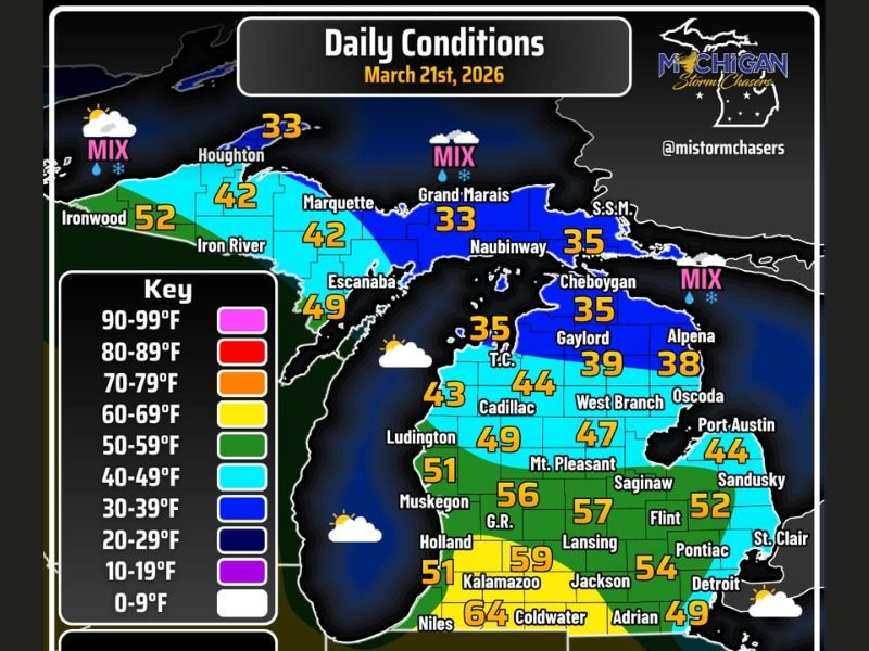
Michigan Weather Swings From Snow and Freezing North to 70°F South Along I-94 as Flood Risk and Thunderstorm Chances Build
MICHIGAN — A dramatic weather split is unfolding across Michigan today, with wintry conditions lingering in the north while much warmer temperatures push into the southern part of the state.
Forecasters say this sharp contrast will bring a mix of snow, rain, gusty winds, and even spring-like warmth near 70 degrees along parts of the I-94 corridor.
Winter-Like Conditions Continue Across Northern Michigan
Northern Michigan, including areas like Marquette, Houghton, and Sault Ste. Marie, is holding onto colder air with temperatures staying in the 30s and low 40s.
A mix of precipitation is expected in parts of the Upper Peninsula, where rain and snow could combine at times. Snow may linger on the ground in northern areas well into April, especially as additional cold systems pass through.
These conditions highlight how winter is not quite finished in the northern half of the state despite the official arrival of spring.
Warmer Air Pushes South With Near 70°F Temperatures
In sharp contrast, southern Michigan is experiencing a surge of warmer air, with temperatures climbing into the upper 50s and even mid-60s in some locations.
Forecasters indicate that parts of the I-94 corridor and areas farther south could approach 70 degrees, offering a preview of spring-like conditions.
Cities such as Kalamazoo, Coldwater, and surrounding communities are among those seeing the warmest readings, creating a noticeable divide across the state.
Flood Concerns Growing in Northern Regions
As warmer air begins creeping northward, concerns are increasing about potential flooding, particularly in areas north of US-10 and across parts of the Upper Peninsula.
Melting snow combined with fluctuating temperatures could lead to rising water levels in rivers and low-lying areas. Officials are monitoring conditions closely as this transition unfolds.
Residents in flood-prone areas are being advised to stay alert and watch for updates, especially as conditions can change quickly during seasonal shifts.
Gusty Winds and Changing Conditions Add to Complexity
In addition to temperature swings, wind gusts of up to 30 mph are possible across parts of the state today. Wind direction is expected to vary, contributing to rapidly changing weather conditions.
While widespread severe weather is not expected today, the combination of wind and temperature contrasts can still create localized impacts, including reduced visibility in wintry areas and shifting conditions for travelers.
Thunderstorm Chances Return by Sunday
Looking ahead, precipitation chances remain relatively low across southern Michigan through Saturday, but that will begin to change as the weekend progresses.
By Sunday, a system moving into the region is expected to bring a chance of thunderstorms, particularly across southern portions of the state.
This transition from snow and cold to potential thunderstorms within a short timeframe underscores the volatile nature of early spring weather in the Midwest.
If you’re experiencing these changing conditions in your area, share your updates with us. Stay connected with SaludaStandard-Sentinel.com for the latest forecasts and breaking weather coverage across the United States.