Michigan Radar Shows Freezing Rain and Snow Expanding Overnight, With Changeover Expected for Northeast Lower Peninsula and Upper Peninsula
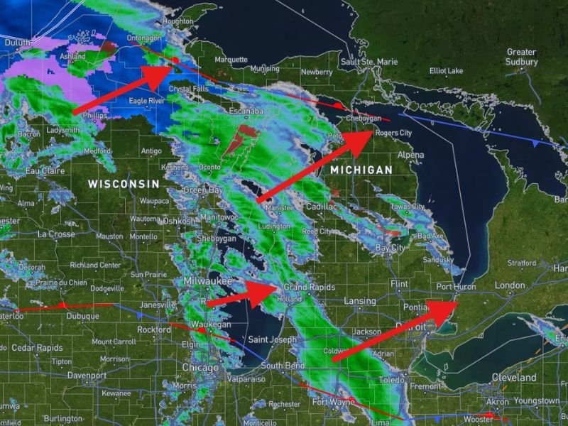
MICHIGAN — A late-night radar update at 12:25 a.m. EST on 2/18/2026 is helping paint a clearer picture of a messy winter mix moving into the region from the southwest, with bands of rain, freezing rain, and snow spreading across parts of Michigan and nearby Wisconsin as the morning progresses.
What Radar Is Showing Right Now
The radar depiction highlights the first organized bands pushing in from the southwest, with rain (green) out ahead, freezing rain (red-violet) mixing in, and snow (blue) expanding across colder areas. The pattern suggests precipitation will continue to fill in rather than remain isolated, meaning more communities could see impacts as moisture increases through the early morning hours.
Changeover Expected For The Northeast Lower Peninsula And The U.P.
Forecasters expect a gradual changeover to all freezing rain and snow in the next few hours for the northeastern Lower Peninsula and the Upper Peninsula. That kind of transition is important because it can turn “just wet roads” into glazed surfaces quickly, especially on bridges, overpasses, untreated side roads, and elevated ramps.
Storms Could Increase South Of A Ludington-To-Thumb Line
The update also notes that a few storms may pop up with time south of a line roughly from Ludington over to the Thumb. If storms become more organized, precipitation rates can increase briefly—raising the risk for fast-forming slick spots where freezing rain is involved and lowering visibility where heavier snow bands develop.
What To Watch For Through The Morning
Conditions may change quickly from county to county depending on exact temperature profiles. The biggest practical hazards are likely to include:
- Icy travel where freezing rain becomes dominant
- Reduced visibility in heavier snow bands
- Rapid shifts in road conditions during the changeover window
If you’re traveling early, slow down and leave extra distance—especially in areas trending toward freezing rain. What are road conditions like where you are right now—wet, slushy, or starting to ice over? Share what you’re seeing and keep checking SaludaStandard-Sentinel.com for additional updates.