Michigan, New York, Massachusetts, Vermont, Connecticut, and West Virginia Braced for Light Snow Through Saturday, With 8 Inches Possible in WV Mountains
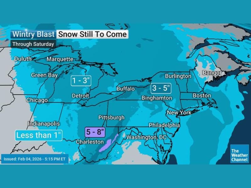
NEW YORK — A low-impact winter system is expected to deliver a light, nuisance snowfall from the Great Lakes into the Northeast through Saturday, with most communities looking at 1–3 inches, a few pockets reaching 3–5 inches, and the highest totals reserved for the mountains of West Virginia, where up to 8 inches is possible.
Snow Totals Stay Modest for Most Areas
A Thursday morning update indicated no major changes to the overall forecast. The most common outcome remains 1–3 inches across a broad zone stretching from parts of the Great Lakes into much of the Northeast.
Forecasters also noted some isolated 3–5 inch amounts are possible in spots influenced by lake enhancement, though expectations are lower for areas tied directly to Lake Erie compared to other lake-adjacent regions.
West Virginia Mountains Could See the Highest Accumulations
While this is not expected to be a major storm for large metro areas, the Appalachian terrain stands out as the place most likely to see more meaningful totals. The forecast highlighted that the mountains of West Virginia could pick up as much as 8 inches, which could lead to slick conditions on higher-elevation roads and passes even if nearby lower elevations see less.
Boston, Burlington, and Albany Still Targeted, With Hartford and NYC Now Watching Closely
The forecast continues to keep Boston (Massachusetts), Burlington (Vermont), and Albany (New York) in the zone most likely to see accumulating snow with this system.
One notable shift in the update was a slightly increased snow potential for cities farther south and west of the core axis, including Hartford (Connecticut) and possibly New York City (New York). Any accumulation in NYC would likely be on the lighter end, but even a quick coating can create slowdowns during peak travel times.
Not a Major Storm, But Enough to Create Travel Headaches
Forecasters emphasized this is not a blockbuster system and that many areas may see little more than advisory-level impacts, if anything at all. However, light snow can still cause problems—especially where temperatures hover near freezing and roads develop spotty slick patches during overnight or early-morning hours.
What are conditions like in your area right now—are you seeing a fresh coating, or is this one mostly missing you? Share what you’re noticing, and keep following updates at SaludaStandard-Sentinel.com.