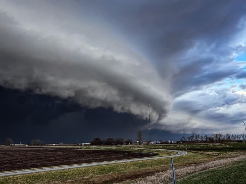
Massive Shelf Cloud Rolls Into Davenport Iowa Signaling Powerful Storm Line With Strong Winds and Sudden Weather Shift
DAVENPORT, IOWA — A dramatic and fast-moving shelf cloud was spotted approaching the west side of Davenport, signaling the arrival of a powerful storm line capable of producing strong winds and rapidly changing conditions.
The striking cloud formation, often referred to as a “monster” shelf cloud due to its size and structure, is typically associated with the leading edge of intense thunderstorms.
Shelf Cloud Marks Arrival of Strong Storm Line
The approaching shelf cloud indicates the presence of a well-organized storm system pushing into eastern Iowa. These formations develop along the gust front of thunderstorms, where cooler air rapidly pushes beneath warmer air, creating a rolling, layered appearance across the sky.
In this case, the cloud’s size and definition suggest a strong outflow boundary, often linked to damaging straight-line winds.
Strong Winds and Sudden Weather Changes Likely
As the shelf cloud moves through Davenport and surrounding areas, residents can expect a sudden increase in wind speeds, often arriving before heavy rain begins.
These winds can be strong enough to bring down small tree limbs, reduce visibility due to blowing dust, and create hazardous travel conditions. The dramatic shift from calm to stormy weather can happen within minutes as the gust front passes.
Heavy Rain and Lightning Expected Behind the Cloud
Following the shelf cloud, the main body of the storm is likely to bring heavy rain and frequent lightning. Localized downpours could briefly reduce visibility and lead to minor water accumulation on roadways. Lightning activity is also expected to increase as the storm core moves into the area.
Not a Tornado but Still a Powerful Indicator
While shelf clouds can appear intimidating and are sometimes mistaken for tornadoes, they are not rotating funnel clouds.
However, they are a strong visual signal that severe or near-severe weather conditions are imminent, particularly strong winds. Residents should treat the arrival of such a feature as a warning to move indoors and secure loose outdoor items.
Storm Continues Moving East Across Region
The storm system is expected to continue pushing eastward beyond Davenport, impacting additional communities across eastern Iowa and into western Illinois.
As it moves, similar conditions—including gusty winds and heavy rain—may develop along its path. Residents in downstream areas should remain alert as the storm progresses.
If you witnessed this shelf cloud or are experiencing storm conditions in Davenport or nearby areas, share your experience and stay updated with more local coverage on SaludaStandard-Sentinel.com.