Massive Arctic Blast to Send U.S. Temperatures Plummeting Up to 40 Degrees Below Normal Later This Week
CHICAGO, IL — Winter is making its presence felt in a dramatic way this week as a massive Arctic air mass descends across the central and eastern United States, bringing some of the coldest temperatures of the season and plunging conditions up to 40 degrees below normal in parts of the Midwest and Great Lakes.
Forecasters say the upcoming cold snap could mark the strongest early December Arctic outbreak in several years, potentially setting new daily temperature records across multiple states.
Arctic Air Plunges Across the Nation
According to model data from Pivotal Weather, temperatures will begin to fall sharply by Thursday as a deep Arctic front pushes southward from Canada.
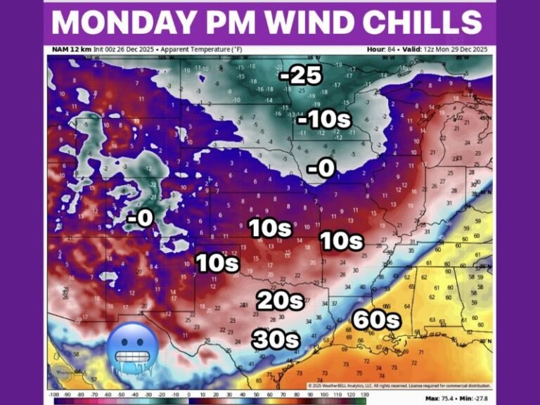
By early Friday morning, widespread temperature anomalies—the difference from normal seasonal averages—could range between 20°F and 40°F below average across the central U.S.
Areas expected to experience the sharpest cold include:
- Upper Midwest and Great Lakes: 30–40 degrees below average
- Central Plains and Midwest: 25–35 degrees below average
- Tennessee Valley and Ohio Valley: 15–25 degrees below average
- Northern Southeast states: 10–20 degrees below average
Meteorologists warn that wind chills will make conditions feel even colder, potentially dipping into the single digits and below zero for millions across the northern tier states.
Frigid Air Extends From the Rockies to the East Coast
The Arctic front will reach from the Northern Rockies through the Midwest and into the Northeast by late Thursday. States such as Minnesota, Iowa, Wisconsin, and Illinois are expected to see daytime highs struggling to rise above the teens and 20s, with overnight lows plunging near or below zero.
By Friday morning, the chill will expand into the Appalachians and the Southeast, including parts of Kentucky, Tennessee, and northern Alabama, where morning temperatures could hover near freezing.
“This is a serious blast of Arctic air,” forecasters said Tuesday. “It’s not just a one-day event—this cold will linger for several days before any real warming begins.”
Potential for Record Cold and Wintry Weather
Several major cities across the Midwest may break record low temperatures for early December.
- Chicago, IL: Forecast lows in the single digits
- Minneapolis, MN: Possible subzero readings
- Kansas City, MO, and Des Moines, IA: Lows near zero
- Cleveland, OH, and Detroit, MI: Lows in the teens
The extreme cold could also set the stage for lake-effect snow around the Great Lakes region, while portions of the Ohio Valley and Appalachians may see light wintry precipitation as the front interacts with moisture.
Safety and Preparedness Alerts Issued
Emergency management officials are urging residents across affected regions to take precautions against frostbite and hypothermia, especially those spending time outdoors or traveling.
The sudden drop in temperature could also cause hazardous driving conditions as wet roads quickly refreeze overnight.
Experts recommend:
- Wearing layers of insulated clothing
- Limiting outdoor exposure for pets and livestock
- Protecting pipes from freezing
- Preparing vehicles with emergency supplies for cold-weather travel
Brief Warm-Up Expected After the Freeze
Forecasters anticipate a temporary rebound in temperatures by early next week as the Arctic high pressure system shifts eastward. Warmer air from the south and west is expected to move in, returning many areas to above-normal temperatures by mid-December.
Still, meteorologists caution that winter has arrived early and forcefully, serving as a reminder of the season’s volatility across the U.S.
Residents are encouraged to stay tuned for local updates and cold-weather advisories through the week.
For continuing national weather coverage and safety updates, visit SaludaStandard-Sentinel.com.