Major Lake-Effect Snow System to Blanket Midwest and Northeast Early Next Week
GREENVILLE, S.C. — A major lake-enhanced snow event is set to unfold early next week, bringing the first widespread snow cover of the season to large portions of the Midwest, Great Lakes, and Northeast, according to forecasts from WYFF 4 Chief Meteorologist Chris Justus.
The storm system, fueled by cold air flowing over the Great Lakes, is expected to begin late Sunday evening and persist through Tuesday, coating multiple states with measurable snowfall.
“This is the first true Great Lakes–enhanced snow event of the season — and it’s going to be impressive,” Justus said in his latest update on Friday.
Snowfall Expected from North Carolina to the Northeast
Forecast models indicate that Western North Carolina, Ohio, Indiana, Michigan, Pennsylvania, and New York will likely see accumulating snow, with the heaviest totals centered around the Great Lakes region.
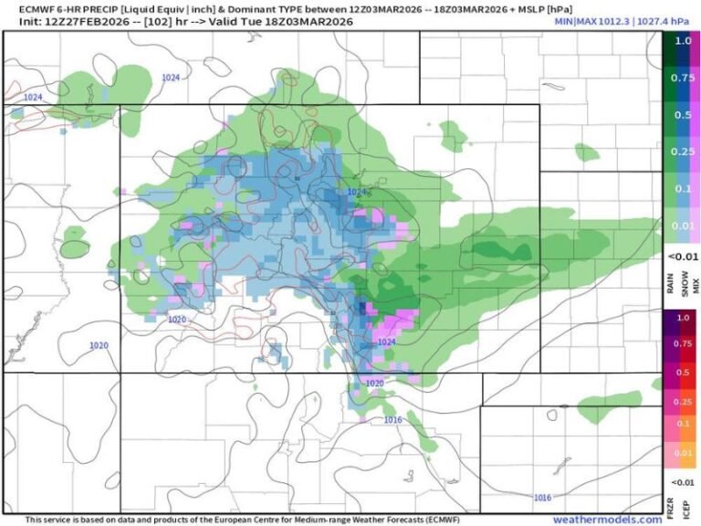
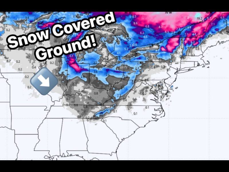
Justus shared a new European Centre for Medium-Range Weather Forecasts (ECMWF) model image showing widespread snow-covered ground expected by Monday night into Tuesday, with totals ranging from 2 to 10 inches in many areas.
“Snow-covered ground is likely for many areas from Western North Carolina into the Midwest and Northeast,” Justus noted, emphasizing that the system could mark the start of persistent winter conditions for northern states.
Cold Air and Lake Moisture Creating Ideal Setup
Meteorologists describe the upcoming event as a classic lake-effect snow setup, where cold Arctic air moves across the relatively warm waters of the Great Lakes, picking up moisture and dumping snow over downwind areas.
This setup often leads to localized heavy snow bands, capable of producing rapid accumulations and whiteout conditions in some communities.
The forecast shows the strongest snow activity developing around Lake Erie and Lake Ontario, with additional accumulation possible along the Appalachian Mountains and into interior sections of the Northeast.
Impacts and Travel Concerns
The timing of the snow — beginning Sunday night and continuing through Tuesday — could cause difficult travel conditions for morning commuters early in the week. Drivers in affected regions are being advised to prepare for slick roads, reduced visibility, and possible travel delays.
Major highways including Interstates 80, 90, and 81 may experience extended travel disruptions due to snow and ice accumulation.
“This will be a multi-day event, not just a quick burst,” Justus cautioned. “Anyone traveling in or near the Great Lakes region should expect winter driving conditions.”
Winter Arrives Early for the Great Lakes
This system marks the first significant winter storm of November and could signal an active early-season pattern for the central and eastern United States. Meteorologists are watching for additional systems that could follow as Arctic air masses push southward through mid-November.
Residents across the Midwest and Northeast are encouraged to check local forecasts frequently, stock up on winter essentials, and allow extra travel time early next week.
The National Weather Service is expected to issue official advisories and warnings as the system approaches.
For live weather updates and regional forecasts, follow SaludaStandard-Sentinel.com for ongoing coverage of this developing winter storm.