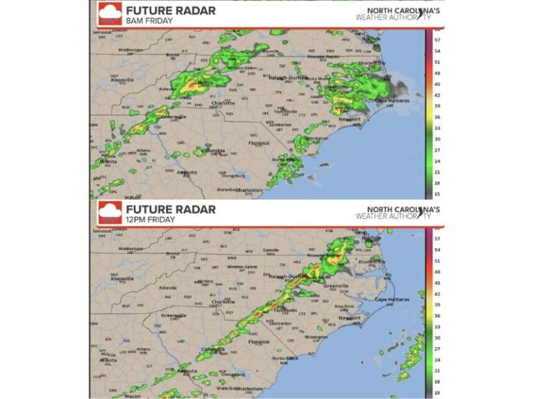
Late-Night Forecast Models Push Snow Totals Higher Along the North Carolina–Tennessee Line as Banding Risk Increases
NORTH CAROLINA–TENNESSEE — Late-night forecast model updates show another upward trend in projected snowfall totals, with several areas now facing the potential for heavier banding that could push accumulations closer to 8 inches, and possibly even 10 inches, as the system moves in on schedule.
While most locations remain within previously forecast ranges, the newest data suggests localized enhancements that could significantly impact parts of the region.
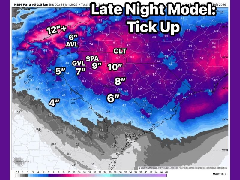
Late-Night Model Data Shows a Noticeable Tick Up
The latest high-resolution guidance indicates a subtle but important increase in snowfall potential. This upward adjustment does not affect the entire region evenly, but instead highlights specific zones where snowfall rates may intensify. These increases are consistent with developing mesoscale features rather than a wholesale shift in the storm’s track.
North Carolina–Tennessee State Line Trending Higher
The most consistent signal for higher totals continues to focus along and near the North Carolina–Tennessee state line, where snow is expected to begin on schedule. This corridor remains favored for enhanced snowfall due to elevation and storm dynamics working together.
Several locations in this zone are now showing totals approaching the upper end of previous forecasts, with isolated pockets potentially exceeding them.
Heavier Banding Could Drive Localized Totals Toward 10 Inches
Forecasters are closely watching the risk of heavier snow banding, which can dramatically increase totals over short distances. Where these bands set up and persist, snowfall amounts could climb well above surrounding areas.
This explains why some spots are now being flagged for totals nearing 8 inches, with the possibility of reaching or exceeding 10 inches if banding becomes established.
Most Areas Still on Track, but Variability Remains
Despite the higher-end signals, the majority of the region remains on track with earlier projections. The late-night increase reflects fine-scale adjustments rather than a major forecast overhaul.
However, this type of setup is known for sharp gradients, meaning small shifts in band placement could result in big differences from one community to the next.
What to Watch Going Forward
As snow begins on schedule, attention will turn to how quickly and efficiently bands develop and whether they linger over the same areas. That evolution will determine where the highest totals ultimately occur.
Further refinements are expected as the event gets closer and real-time observations begin to replace model projections. For continued updates, local impacts, and timing details as this winter system unfolds, stay with SaludaStandard-Sentinel.com.