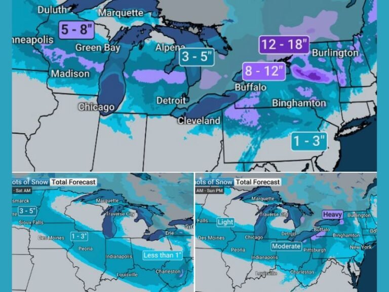
Kentucky Snowfall Forecast Clarifies as Two-Phase Winter System Targets Mountains With Higher Totals Through February 1
KENTUCKY — After several days of uncertainty, meteorologists have released a more refined snowfall forecast for Kentucky as a two-stage winter system is expected to impact the region from Friday through early Sunday, bringing an initial band of snow followed by heavier accumulation in eastern and southeastern mountain areas once a coastal low strengthens.
The updated forecast reflects improved confidence in storm structure and snowfall distribution, particularly across higher elevations where totals are now trending higher.
Two-Phase Storm Setup Explained
Forecasters expect the event to unfold in two distinct stages. The first phase arrives Friday as a fast-moving disturbance sweeps through the Ohio Valley, triggering a broad initial band of light snow across much of the state.
The second phase develops as a coastal low strengthens later in the weekend. As that system deepens, moisture is expected to wrap back into the Appalachian region, allowing heavier snowfall to reach the eastern and southeastern Kentucky mountains.
Snowfall Ranges by Region
The updated snowfall map highlights clear accumulation zones across the state.
Western and central Kentucky, including areas such as Paducah, Owensboro, Bowling Green, Elizabethtown, and Louisville, are expected to see a light coating up to around one inch, primarily from the initial snow band.
Across south-central and parts of eastern Kentucky, including Somerset, London, Richmond, and surrounding communities, snowfall totals are projected in the 1 to 3 inch range, with accumulation increasing closer to the Cumberland Plateau.
The highest totals are expected in far eastern Kentucky, including areas near Hazard, Harlan, Pikeville, and adjacent mountain communities, where 3 to 5 inches of snow is now forecast. These totals reflect the added influence of the developing coastal system pulling moisture inland.
Why Mountain Totals Are Trending Higher
As the coastal low intensifies, colder air aloft and upslope flow will enhance snowfall efficiency in higher elevations. This setup allows snow to fall more steadily and accumulate faster in mountain zones compared to lower elevations farther west.
Forecasters note that while the initial snow band will be relatively light, the second phase will be responsible for the bulk of accumulation in eastern Kentucky.
Timing and Travel Impacts
Snow is expected to begin Friday, with lighter accumulations spreading west to east. Heavier snowfall in the mountains is most likely from late Friday night into Saturday, with lingering snow possible into early Sunday.
Travel impacts are expected to be most significant in eastern Kentucky, where snow-covered roads, reduced visibility, and colder temperatures could create hazardous conditions, particularly overnight and during early morning hours.
What to Watch Going Forward
While confidence has increased, meteorologists will continue monitoring the exact placement of the heavier snow axis, as even small shifts in storm development could adjust totals slightly.
Residents are encouraged to prepare for winter travel conditions, especially in mountain regions where snow removal can be slower and road conditions may remain slick after snowfall ends.
Stay with SaludaStandard-Sentinel.com for continued updates, refined snowfall totals, and the latest winter weather advisories as this system unfolds.