Jet Stream Shift to Bring Cold, Stormy Weather to Midwest and Northeast While Texas Turns Warm and Dry Next Week
UNITED STATES — A significant jet stream shift is setting the stage for a sharp weather divide next week, bringing cold and stormy conditions to the Midwest and Northeast while states such as Texas settle into a warm, dry pattern with above-normal temperatures. The contrasting setup will influence weather across much of the country from mid-week through next weekend.
Arctic Air Strengthens Over the Midwest and Northeast
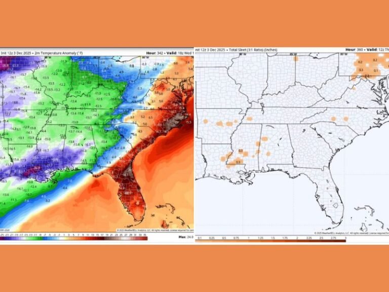
Meteorologists report that a persistent Arctic air mass will continue pushing southward into the Upper Midwest, Great Lakes, and Northeast, reinforcing what has already been a wintry stretch for millions. Updated forecast maps show the jet stream dipping deeply across the central and eastern United States, funneling cold, storm-producing air directly into regions including Minneapolis, Chicago, St. Louis, New York, and Washington.
This incoming pattern will support snow showers, brisk winds, and below-normal temperatures for several days. Forecasters warn that the combination of Arctic air and storm energy could generate periods of hazardous travel, especially for communities along the Great Lakes and interior Northeast. The system’s alignment allows repeated waves of moisture to interact with cold air, increasing the potential for multiple rounds of winter weather.
Texas and the Southwest Expected to Warm Under Dry, Sunny Conditions
While the eastern half of the nation braces for a prolonged chill, the forecast for Texas, New Mexico, Arizona, and much of California moves in the opposite direction. These areas fall under the warm and dry side of the jet stream, a position that typically brings clear skies, rising temperatures, and minimal rainfall.
Cities such as Austin, Dallas, El Paso, Los Angeles, and San Francisco are expected to experience above-average daytime highs, along with plenty of sunshine through mid-week and beyond. The warm ridge building over the region suggests that outdoor conditions will remain stable and pleasant, making next week’s weather notably different from the storm-impacted northern states.
Forecasters emphasize that the sharp temperature contrast shown on next week’s maps reflects a classic wintertime pattern in which the jet stream separates warm, stable air to the south from cold, active weather to the north. This setup often persists for several days once established.
A Divided Weather Pattern to Shape U.S. Conditions Through Next Weekend
With Texas and the Southwest warming up and the Midwest and Northeast facing another round of winter-driven storms, next week’s weather will feel dramatically different depending on location. The jet stream’s path is expected to hold steady into next weekend, meaning continued cold and storm chances in the north and continued warmth and dryness in the south.
Have you already seen signs of this pattern developing where you live? Share your observations and stay updated with the latest national forecasts at SaludaStandard-Sentinel.com.