Jet Stream Shift to Bring Arctic Air Midweek Followed by Atmospheric River and Heavy Rain Risk Across the U.S., With North Georgia Expected to See Above-Average Rainfall
UNITED STATES — A significant shift in the jet stream is expected over the next week, bringing a sharp drop in temperatures midweek before a surge of warm, moisture-loaded air arrives by next weekend. The evolving pattern will affect large portions of the country and may result in above-average rainfall, particularly across north Georgia.
Arctic Air Expected Midweek as Jet Stream Dips South
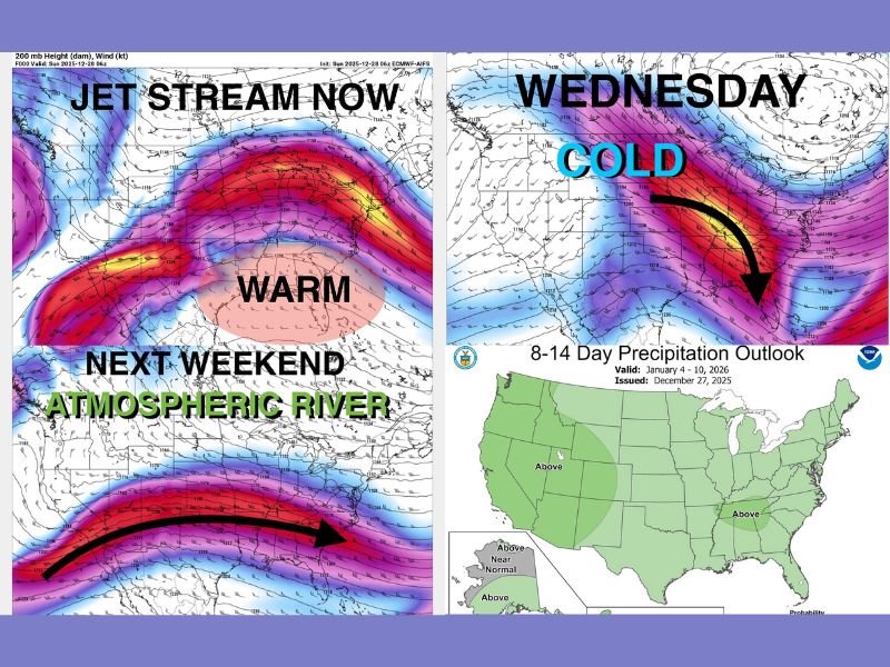
Meteorologists report that the jet stream, which is currently positioned far to the north allowing warm tropical air to move across the South, will soon plunge southward from Canada, opening the door for cold Arctic air to move across much of the nation.
This shift will create much colder conditions by Wednesday, particularly across the central and eastern United States. The incoming cold air may lead to widespread temperature drops and a transition to more winterlike conditions.
Atmospheric River Pattern Setting Up by Next Weekend
Following the midweek cold surge, temperatures are expected to rise again as an atmospheric river develops.
An atmospheric river is a long, narrow band of moisture-rich air that transports significant water vapor from the Pacific Ocean across the United States.
Key characteristics include:
- High moisture content concentrated in a narrow corridor
- Transport of warm oceanic moisture far inland
- Potential for heavy rainfall or high-elevation snowfall once the moisture reaches land
This pattern may produce substantial rainfall totals, especially where the moisture band stalls or repeatedly passes over the same region.
Above-Average Rainfall Expected Nationwide, Especially in North Georgia
The Climate Prediction Center now forecasts above-average precipitation for nearly the entire United States, with north Georgia highlighted as one of the regions most likely to see higher rainfall totals. This combination of Arctic air followed by a moisture-loaded atmospheric river could produce:
- Heavy rain events
- Localized flooding risks
- Snow or mixed precipitation in colder northern regions
Forecast confidence will increase as the atmospheric river begins to organize later in the week.
A Week of Rapid Weather Changes
The upcoming weather pattern shift will be notable for its rapid transitions:
- Warm, tropical-influenced air currently dominating
- Cold Arctic air arriving midweek
- A sharp warm-up as the atmospheric river establishes
- Potential for significant rainfall nationwide
Meteorologists advise residents to prepare for a dynamic week with changing temperatures, shifting precipitation types, and increased moisture impacts. For continued coverage and detailed updates, visit SaludaStandard-Sentinel.com.