Illinois Supercell Near Joliet Triggers Rare PDS Tornado Warning as Powerful Storm Targets Indiana and Ohio Overnight
ILLINOIS — A powerful rotating thunderstorm developed across northeastern Illinois, prompting meteorologists to issue a rare PDS (Particularly Dangerous Situation) tornado warning after radar indicated a large and potentially destructive tornado just south of Joliet.
The intense supercell storm quickly drew attention from forecasters because of its exceptionally strong radar signature, which meteorologists described as unusually impressive for early March. The storm formed within a volatile atmospheric environment capable of producing organized severe weather as it moved across the region.
Rare PDS Tornado Warning Issued South of Joliet
Meteorologists issued the PDS tornado warning after radar and storm reports indicated a confirmed tornado within the supercell storm. A PDS designation is reserved for the most dangerous tornado situations, signaling that the storm could produce significant damage and life-threatening conditions.
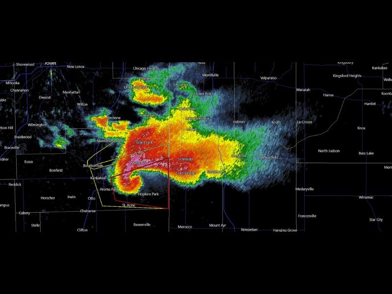
The warning area included communities south of Joliet, where the storm rapidly intensified and developed a strong rotational structure. Radar imagery showed a classic supercell formation with an intense core and a well-defined hook-like structure — features commonly associated with tornado-producing storms.
Storm chasers and meteorologists monitoring the system described the radar presentation as extremely powerful, indicating a storm capable of producing a large tornado.
Radar Signature Shows Intensifying Supercell Structure
Weather radar images revealed a striking storm structure with heavy precipitation and intense rotation embedded within the supercell. Bright red and orange reflectivity cores indicated extremely heavy rain and hail, while the storm’s curved shape suggested strong rotational dynamics.
The storm appeared to strengthen as it moved southeast across parts of northeastern Illinois. Areas including Kankakee and nearby communities were positioned near the storm’s path as meteorologists monitored the evolving system closely. Such radar patterns often signal storms capable of producing destructive tornadoes, particularly when combined with strong wind shear and unstable air in the lower atmosphere.
Storm Expected to Track Into Indiana and Toward Ohio
Forecasters expect the storm system to continue moving eastward through the night. After crossing northeastern Illinois, the powerful supercell is forecast to push into Indiana and potentially continue toward Ohio later tonight.
Meteorologists warn that the atmospheric environment ahead of the storm remains favorable for organized severe weather. This means the storm could maintain strength or potentially produce additional severe hazards as it travels across state lines. Severe thunderstorms embedded within the system may also bring damaging winds, hail, and dangerous lightning in addition to tornado potential.
Meteorologists Call Radar Presentation “Wild”
Weather experts tracking the storm noted that the radar presentation during the event was unusually intense. Strong radar returns and persistent storm rotation made the storm stand out compared to typical early-season thunderstorms.
Situations like this often occur when multiple atmospheric ingredients align, allowing storms to grow quickly and develop strong rotating updrafts. Even experienced meteorologists noted that the storm’s radar appearance was particularly striking, underscoring the seriousness of the severe weather threat as the system moves eastward.
Residents across Illinois, Indiana, and nearby regions are urged to remain weather aware as the storm progresses. Tornado warnings and severe weather alerts can change rapidly during active storm outbreaks. Readers who experienced the storm or witnessed severe weather in their communities can share their experiences and follow continued updates at SaludaStandard-Sentinel.com.