Illinois Indiana Kentucky Missouri Ohio Storm Threat Builds Sunday as ECMWF Signals Damaging Wind Risk and Possible Tornado Development
ILLINOIS, INDIANA, KENTUCKY, MISSOURI, OHIO — A potentially dangerous storm setup is beginning to take shape across parts of the Midwest and Ohio Valley as new ECMWF guidance indicates storms could rapidly develop Sunday afternoon into the evening, bringing a primary threat of damaging winds along with a possible tornado risk.
ECMWF Signals Cap Breaking and Rapid Storm Development Sunday
Forecast data shows that atmospheric conditions may shift quickly on Sunday, allowing a “cap” — a layer of warm air that suppresses storm formation — to break during the afternoon hours.
Once that cap erodes, storms are expected to develop quickly, particularly across southern Illinois and nearby regions. This type of setup often leads to explosive storm growth, especially when combined with strong instability and wind energy in the atmosphere.
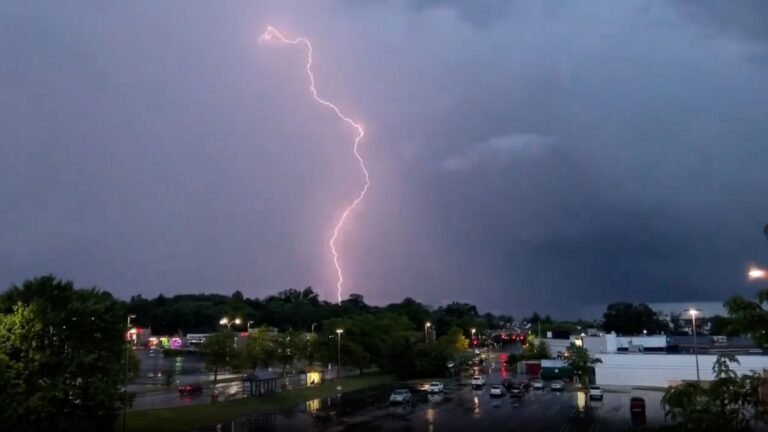
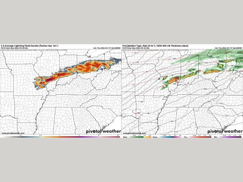
Lightning Density Maps Highlight Intense Storm Corridor
Model projections of lightning flash density show a concentrated corridor of intense thunderstorm activity stretching from Missouri through Illinois into Indiana and Ohio.
This corridor suggests that storms may organize into a more structured system rather than remaining scattered, increasing the likelihood of widespread impacts across multiple states.
The strongest signals appear across southern Illinois into central Indiana and western Ohio, where the highest storm intensity may occur.
Damaging Winds Expected to Be the Primary Threat
Forecast soundings and model guidance strongly favor damaging straight-line winds as the main hazard with this system.
There is growing concern that storms could organize into a mesoscale convective system (MCS), which is capable of producing widespread wind damage over a large area.
If this occurs, communities across Illinois, Indiana, Kentucky, Missouri, and Ohio could see strong wind gusts capable of downing trees, damaging structures, and causing localized power outages.
Tornado Risk Cannot Be Ruled Out
While damaging winds appear to be the dominant threat, forecasters are not ruling out the possibility of tornado development. Embedded rotation within storm lines or isolated supercells could produce brief tornadoes, especially in areas where wind shear and instability overlap.
Southern Illinois and adjacent regions currently appear to have the highest potential for this added risk, though conditions may evolve as the system develops.
Storm Timing and Regional Impact Areas
Current projections suggest storms will begin developing Sunday afternoon, intensifying into the evening hours as they move eastward.
Missouri and Illinois are expected to see the earliest development, followed by impacts spreading into Indiana, Kentucky, and Ohio later in the evening and overnight. Residents across these states should remain alert as timing and intensity details may continue to shift with updated forecasts.
Residents Urged to Stay Alert as Situation Evolves
With multiple hazards possible, including damaging winds and isolated tornadoes, residents are encouraged to monitor forecasts closely and be prepared for rapidly changing conditions.
This setup has the potential to impact several states at once, making it important for communities across the Midwest and Ohio Valley to stay weather-aware. Stay tuned to SaludaStandard-Sentinel.com for continuing updates as new data becomes available and the Sunday storm threat becomes clearer.