Illinois, Indiana and Surrounding Midwest States Face Multi-Day Severe Storm Pattern With Cold Front Triggering Storm Chances Tuesday and Wednesday
ILLINOIS AND INDIANA — A developing weather pattern across the Midwest is expected to bring multiple rounds of storm chances this week, with Tuesday and Wednesday emerging as key days to watch as a cold front moves through the region.
Forecasters indicate that while there are increasing opportunities for severe weather, the situation is not expected to resemble a historic large-scale outbreak, but rather a series of daily storm chances that could bring localized impacts.
Active Pattern Sets Stage for Repeated Storm Chances
The overall setup across the Midwest points to an active stretch of weather, with conditions favorable for multiple rounds of storms over several days. This pattern suggests that instead of one major event, communities could see repeated chances for thunderstorms.
This includes areas across Illinois, Indiana, and nearby regions where atmospheric instability will be present, allowing storms to develop at different times depending on how weather systems evolve.
No Major Historic Outbreak Expected
Despite early concerns, forecasters emphasize that this system is not expected to become a large, historic outbreak similar to major past events. Instead, the threat appears more scattered and dependent on daily conditions.
This means that while some storms could still become strong, the overall risk is more conditional and spread out over time rather than concentrated into one high-impact event.
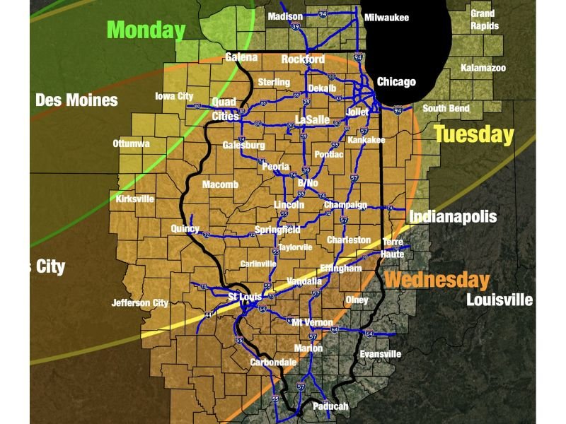
Tuesday Emerges as First Key Day to Watch
Tuesday is currently being highlighted as an important day for storm development, although details remain uncertain. Forecast guidance suggests there could be favorable conditions for storms, but the exact location and intensity will depend on how earlier weather activity unfolds.
Residents are being advised to keep Tuesday on their radar, as changes in the track of systems could shift the risk west or east across the region.
Cold Front Could Trigger Additional Storms Wednesday
By Wednesday, a cold front is expected to move eastward through the Midwest, which could act as a trigger for additional storm development. This front may provide the necessary lift for thunderstorms to form, especially if enough moisture and instability are present.
However, forecasters note that Wednesday’s setup will depend heavily on what happens Tuesday, meaning confidence in exact impacts remains moderate at this stage.
Residents Encouraged to Stay Weather-Aware
With multiple days of potential storm activity, residents across Illinois, Indiana, and surrounding states should remain alert to changing forecasts. Even though no single day currently stands out as extreme, the cumulative effect of repeated storms could still bring disruptions.
Monitoring updates and being prepared for sudden changes in weather conditions will be important, especially during peak afternoon and evening hours when storms are most likely to develop.
If you’re experiencing changing weather conditions in your area, share your updates with us at SaludaStandard-Sentinel.com and help keep your community informed.