HRRR Shows Aggressive Gulf-Effect Snow Bands Near Tampa as Rare Flurry Potential Emerges Across West-Central Florida
FLORIDA — New high-resolution HRRR model data early Sunday morning is drawing attention across west-central Florida as aggressive Gulf-effect snow bands appear capable of producing flurries near the Tampa Bay region, an extremely rare setup for the state.
While confidence in meaningful accumulation remains low, the signal itself is notable enough to warrant close monitoring as cold air continues to interact with moisture off the Gulf of Mexico.
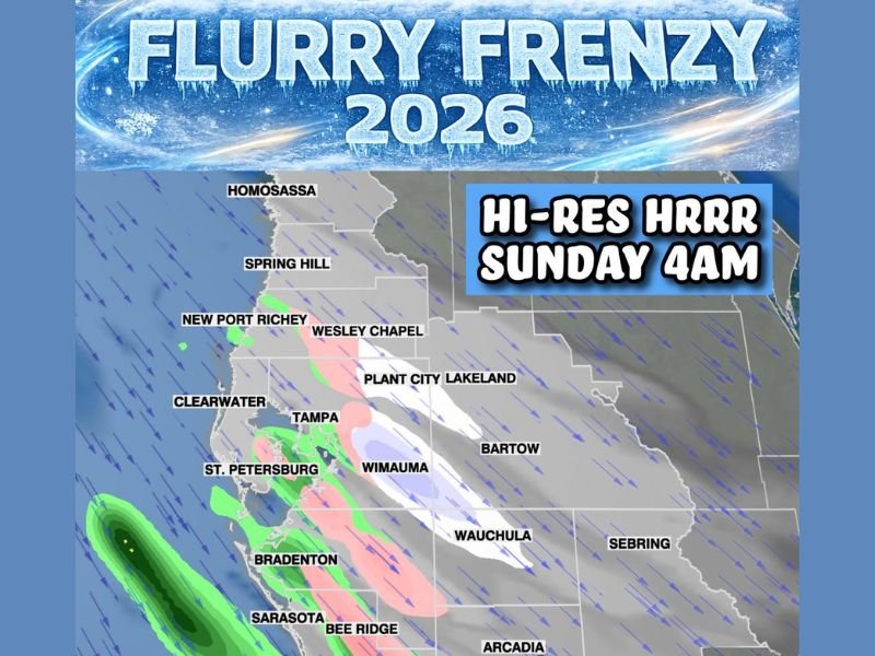
Hi-Resolution HRRR Highlights Narrow Gulf-Effect Snow Bands
The latest HRRR run depicts narrow but intense precipitation bands developing offshore and pushing inland across areas including Tampa, St. Petersburg, Bradenton, Sarasota, and Plant City, with snow indicated within the coldest cores of the bands.
These features resemble lake-effect processes more commonly seen in northern states, driven by strong temperature contrasts between cold air aloft and relatively warm Gulf waters.
Inland Flurries Possible but Model Biases Remain a Concern
While the HRRR suggests snow reaching inland communities, forecasters caution that the model is known to overdo precipitation intensity, especially in marginal setups like this.
As a result, many locations may only see brief flurries or mixed precipitation rather than sustained snowfall. Even so, the mere presence of snow bands in Florida is highly unusual and reflects the strength of the cold air mass in place.
Tampa Bay Area Sits Near the Best Overlap of Cold Air and Moisture
The placement of the bands shows the Tampa Bay region near the best overlap of cold temperatures and incoming Gulf moisture early Sunday morning. This raises the possibility of short-lived flurries, particularly in heavier bursts, though surface temperatures will play a critical role in whether snowflakes survive to the ground.
No significant accumulation is expected based on current guidance.
Cold Air Mass Remains the Dominant Weather Story
Despite excitement around flurry potential, meteorologists emphasize that the cold itself remains the primary hazard, with freezing temperatures and dangerous wind chills already impacting much of the region.
Any snow that does occur would be brief and mainly symbolic, serving as a reminder of how anomalous this winter pattern has become. For continued updates as high-resolution models refine this rare Florida setup, stay with SaludaStandard-Sentinel.com, where we will track changes and impacts as they develop.