High-Resolution Models Show 2–4 Inches of Rain Possible Across North Texas, Southern Oklahoma, and Western Arkansas Sunday Into Monday
TEXAS — New high-resolution weather guidance indicates that northwest and north Texas, southern and central Oklahoma, and portions of western Arkansas could see the highest rain totals beginning Sunday afternoon and continuing into Monday.
Meteorologists say this corridor is shaping up to be the primary zone for heavy rainfall, with 2 to 4 inches possible in several counties.
Band of Heaviest Rain Extends From the Texas Panhandle Through Oklahoma Into Arkansas
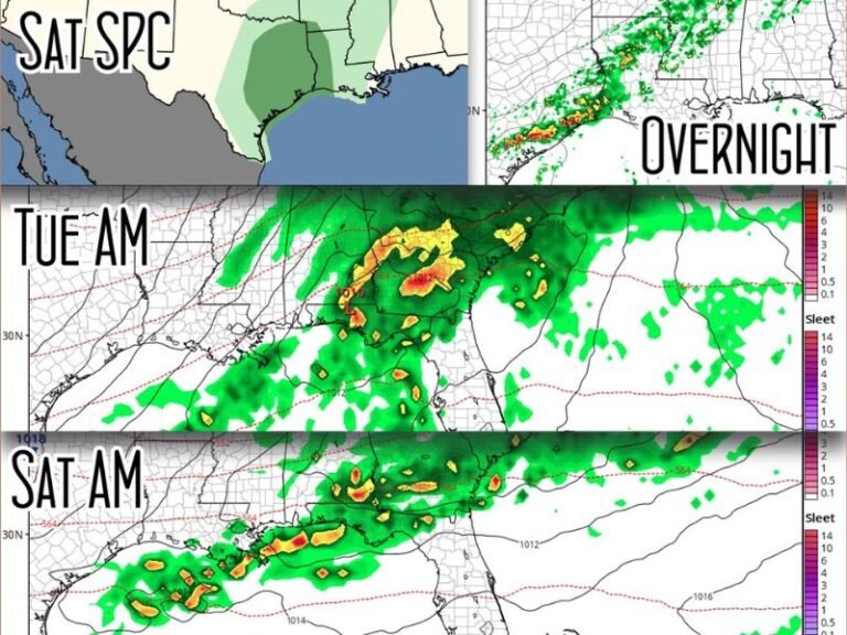
According to high-resolution model output shared by regional meteorologists, a concentrated band of heavy rain is expected to stretch from Amarillo and Lubbock across Abilene, Fort Worth, Dallas, and into southern, central, and eastern Oklahoma, before continuing toward Fort Smith and western Arkansas.
The map highlights a swath where rainfall efficiency is expected to be highest, producing widespread totals exceeding 2 inches and localized totals closer to 4.
North Texas Positioned Directly in the Core Rainfall Zone
Cities including:
- Abilene
- Brownwood
- Fort Worth
- Dallas
- Killeen
- Waco
are all positioned within the elevated-rainfall corridor.
Forecasters say moisture transport and storm development across the region will lead to steady, sustained rainfall, with repeated rounds expected through Monday morning.
Areas just south of the main band — such as Austin, San Antonio, and College Station — will still see rain, but generally lighter totals compared to the northern counties.
Southern and Central Oklahoma Could See Significant Accumulation
In southern and central Oklahoma, including regions near:
- Oklahoma City
- Lawton
- Ardmore
- Bartlesville
- Tahlequah
the same rain band is projected to drop 2 to 4 inches, with some models indicating slightly higher totals in localized pockets.
Forecasters say this is a well-organized system with support from upper-level dynamics that favor widespread precipitation.
Western Arkansas Included in the Heavy Rain Outlook
The heavy rain axis also extends into western Arkansas, where towns near Fort Smith may experience several inches of rainfall as the storm pushes eastward.
Meteorologists say this part of the state often receives enhanced totals when moisture from Texas systems lifts northeast into the Ozarks.
Most Areas in the Region Expected to See Rain
While the heaviest band is clearly defined, forecasters say most counties across the broader region — including South Texas, the Hill Country, and eastern Oklahoma — will still receive meaningful rainfall, even if totals remain lower than the 2–4 inch core.
This setup should help replenish soil moisture and benefit local reservoirs after recent dry stretches.
Rainfall Expected to Continue Into Monday
Rain is expected to begin Sunday afternoon, increase in coverage Sunday night, and continue into Monday.
Forecasters will monitor whether embedded thunderstorms enhance rainfall rates in certain areas.
Residents across Texas, Oklahoma, and Arkansas are encouraged to track updated forecasts as the system approaches.
If you want to share rain totals or conditions from your area once the system moves through, join the conversation at SaludaStandard-Sentinel.com.