Heavy Snow Targets Wisconsin While Michigan Awaits 1–3 Inches Tonight Along I-96 and I-69 Corridor
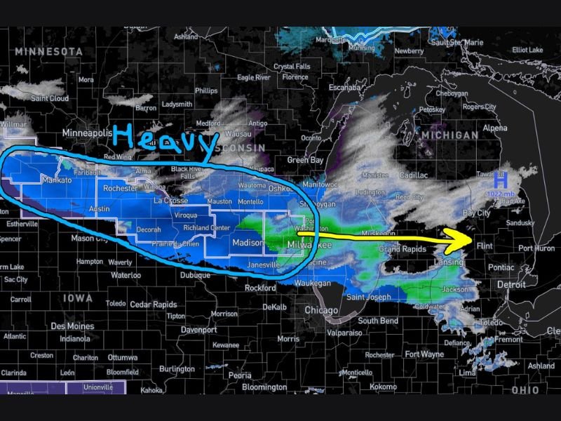
MICHIGAN — A developing winter system is bringing heavy snowfall to western Wisconsin this afternoon, while much of Michigan is still seeing mainly virga — precipitation evaporating before reaching the ground due to dry lower-level air.
Meteorologists report that the deeper moisture needed for steady snowfall remains centered over Lake Michigan and into Wisconsin. As of late afternoon, radar has shown widespread precipitation aloft, but surface-level dryness has limited accumulation across many Michigan communities.
Western Wisconsin Sees Significant Snowfall Totals
To the west, snowfall has been ongoing for much of the day across Wisconsin. Most areas are reporting between 1 and 3 inches so far, but isolated towns have measured higher totals of 4 inches, 6 inches, and even up to 9 inches in select western Wisconsin locations.
These heavier totals appear to be confined primarily west of Lake Michigan, where atmospheric moisture and lift have been stronger throughout the day.
Michigan Expected to See 1–3 Inches, Heavier Totals Unlikely
Across Michigan, forecasters still expect most areas to receive between 1 and 3 inches of snow as the system progresses this evening. The primary track of steadier precipitation is expected to move down the I-96 and I-69 corridor later tonight.
Heavier snowfall is not expected to begin until after 5 p.m. EST. As of 3:49 p.m. EST on February 28, only lighter or intermittent precipitation had reached parts of the state.
The probability of any Michigan city receiving more than 6 inches — let alone 9 inches — from this system is considered very low, estimated at roughly 1-in-100. However, forecasters caution that localized overperformance is always possible with narrow snow bands.
Evening Commute and Overnight Travel Could Be Impacted
As steadier snow arrives later this evening, travel conditions may gradually deteriorate, especially along highways and secondary roads in central and southern Michigan.
Drivers along the I-96 and I-69 corridors should prepare for reduced visibility and accumulating snow during the nighttime hours. While this is not expected to be a major winter storm for Michigan, enough snowfall is likely to create slick spots by late evening.
Residents are encouraged to monitor local forecasts for updates as the system shifts eastward.
Have you started seeing snow in your area tonight? Let us know what conditions are like where you are by sharing your update at SaludaStandard-Sentinel.com.