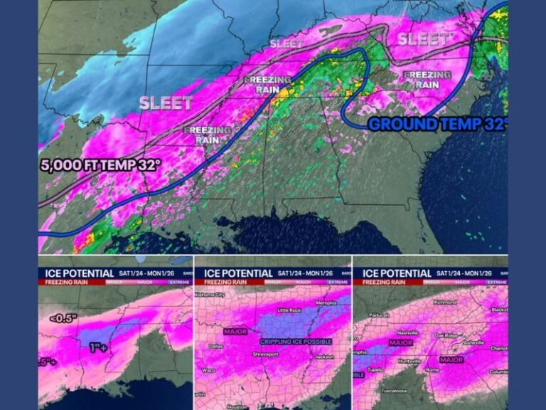
Heavy Snow Forecast This Weekend for Tennessee, Kentucky, North Carolina, and Ohio — Over 12 Inches Possible in Some Areas
NASHVILLE, Tenn. — Weather experts are warning that a major snowfall event could impact large parts of Tennessee, Kentucky, North Carolina, and Ohio beginning late this weekend, with some higher-elevation regions expecting over a foot of snow by Monday morning.
Meteorologists say the upcoming storm is shaping up to be one of the strongest early-season systems of the year, fueled by cold air moving in behind a deep trough.
Forecast Models Show Snow Totals Increasing
New data from European and U.S. weather models shows strong agreement on where the heaviest snow will fall. Updated projections indicate widespread 1–3 inch totals across the lower elevations, while the Appalachian highlands and foothills could see 6–12 inches or more.
In some parts of northern North Carolina and eastern Kentucky, forecasters say the snowfall amounts are trending even higher, with localized totals potentially exceeding 12 inches by late Monday.
“Grass and trees will likely get coated, but roads could stay manageable at first,” forecasters said. “Still, with temperatures this cold, slick spots and icy patches are possible — especially overnight.”
Expected Impact by Area
- Tennessee: Flurries and light snow possible across middle and eastern Tennessee, with heavier accumulation near the Smoky Mountains.
- Kentucky: Central and eastern regions could see 2–6 inches, with higher totals near the state border.
- Ohio: Moderate snow expected across northern counties; slick conditions likely during the overnight hours.
- North Carolina: The western mountains and high country could receive 6–12 inches or more, especially in the Boone and Asheville areas.
Forecasters also note that areas above 2,000 feet in elevation will see the greatest impact, with potential for significant snowdrifts in the Smokies.
School Delays and Travel Concerns
Officials caution that school delays and travel disruptions may occur early next week, particularly in higher elevations where roads may remain snow-covered through Monday morning.
Drivers should plan ahead, allow extra time for morning commutes, and remain alert to potential icy bridges and secondary roads.
This storm is expected to move eastward by early next week, though lingering flurries and gusty winds could persist across the mountains through Tuesday.
Are you preparing for the snow this weekend? Share your photos, local updates, and weather reports with us at SaludaStandard-Sentinel.com.