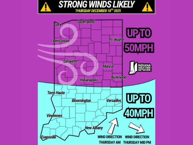
Heavy Snow Building Up at Mammoth Mountain, California as Storm Patterns Shift Favorably for More Accumulation
MAMMOTH MOUNTAIN, CALIFORNIA — Snow is rapidly accumulating across Mammoth Mountain as a new storm system moves into the Sierra Nevada, signaling a shift toward a more favorable pattern for significant snowfall through the upcoming weekend and into next week.
Meteorologists say the recent changes in the evolution of the upper low-pressure system have dramatically improved snow potential for the region. Earlier this week, an unfavorable atmospheric flow limited snowfall amounts, but those conditions are now giving way to a stronger cold-air pattern and enhanced moisture feed.
Weather Pattern Shifts Bring Stronger Snow Chances
The latest satellite and surface data show that the upper low system—which initially suppressed precipitation—has begun to reorient itself, allowing moisture from the Pacific Ocean to surge into California’s higher elevations. This development means Mammoth could see multiple rounds of snow showers and steady accumulation over the coming days.
“Things are beginning to ramp up, and snow potential will be much more favorable going into the weekend,” forecasters noted in the latest local update.
The National Weather Service has also hinted at the possibility of heavier snow bands setting up across Mono County and the eastern Sierra, with visibility reductions and slick travel conditions likely in the higher passes.
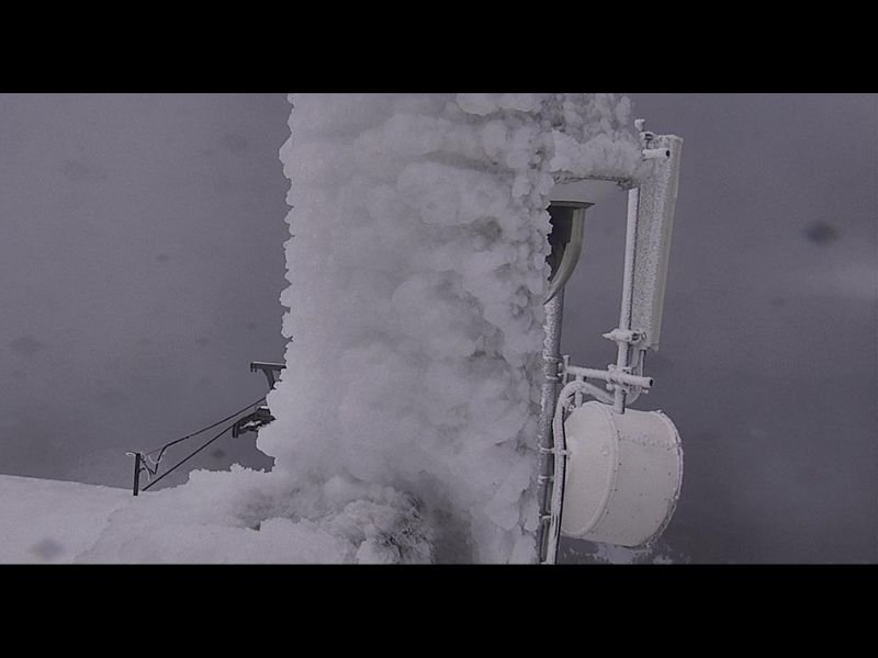
Ski Resorts and Travelers on Alert
Mammoth Mountain Ski Area, one of the most popular ski destinations in California, has already reported fresh accumulation along its upper slopes. Resort operators say crews are monitoring weather conditions closely as temperatures drop and snowpack begins to solidify at higher altitudes.
Images from local weather cameras show icy buildup along mountain infrastructure, confirming that temperatures have remained below freezing throughout much of the day and night.
For travelers, the combination of colder temperatures and snow showers could make for challenging driving conditions on Highway 395 and nearby mountain access roads. Officials are advising motorists to carry tire chains and prepare for potential delays.
More Snow Expected Into Next Week
Forecasters say the snowy pattern is likely to persist well into next week, thanks to a continuing west-to-east jet stream setup that will funnel cold air across the region. By early next week, snow totals across Mammoth and nearby elevations could reach several inches to over a foot in some areas.
While the snowfall will benefit California’s early ski season and regional snowpack, it may also bring periods of heavy wind and low visibility across the central Sierra.
Preparing for a Wintry Stretch
Meteorologists say this developing pattern could mark the start of a more sustained snow season heading into late November. “Once the upper-level trough locks into place, the Sierra should see repeated waves of moisture that will favor snowfall instead of rain,” one forecaster explained.
Residents and visitors are urged to keep up with local weather alerts and plan accordingly as conditions continue to evolve.
Stay updated on California’s changing winter weather patterns and travel advisories at SaludaStandard-Sentinel.com.