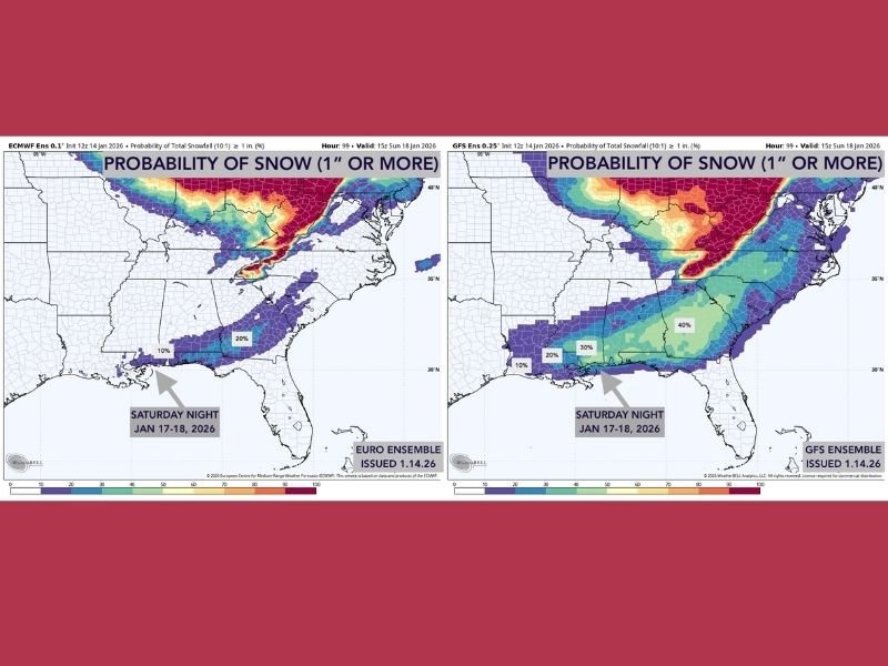
Gulf Coast Facing Uncertain Snow Potential Saturday Night as GFS Shows 30–40% Chances and Euro Holds Near 10%
ALABAMA — Forecast models continue to struggle with the possibility of snow along the Gulf Coast on Saturday night, leaving meteorologists cautious as probabilities shift once again. Earlier this week, models backed away from a wintry scenario entirely, but the newest data now hints at renewed potential — though no guarantees exist at this stage.
Snow Probabilities Split: GFS Shows 30–40%, Euro Near 10%
The two ensemble maps in the update show significant differences between the GFS ensemble and the Euro ensemble:
- The GFS ensemble has increased snow probabilities to 30–40% for parts of the region.
- The Euro ensemble remains considerably drier, keeping probabilities closer to 10%.
Both maps represent ensemble output — meaning each model was run multiple times to generate a range of possible outcomes. The wide spread between the two highlights the high uncertainty surrounding the forecast.
Cold Air and Moisture Must Line Up at the Same Time
According to the discussion, the setup depends heavily on timing and moisture placement:
- A surge of cold air is expected to move in Saturday.
- By Saturday night, an upper-level disturbance is projected to track across the Gulf Coast.
- Snow would only occur if the deep cold air arrives early enough before the disturbance; otherwise, temperatures would be too warm.
Meteorologists stress that cold air and moisture rarely line up perfectly for Gulf Coast snowfall, making this a challenging forecast.
Moisture Availability Still a Major Unknown
Models also disagree on how much moisture will be available:
- Some runs suggest limited moisture.
- Others show the upper-level disturbance may not be strong enough to lift moisture over the cold air.
This inconsistency is one of the main reasons confidence remains low.
Event Will Not Resemble Last Year’s Snowstorm
The update notes that the current setup does not look as cold as last year’s snow event, meaning any snow showers that occur would likely produce limited accumulation, mainly on grassy or elevated surfaces rather than roads.
Forecast Could Change Quickly as Saturday Approaches
Meteorologists caution that this system is still several days away, and model trends could shift significantly. The message emphasizes that this is something to watch closely, but not something to rely on yet.
The Saluda Standard-Sentinel will continue monitoring model updates and provide new information as confidence changes. Readers are encouraged to share whether their area is preparing for a possible wintry mix at SaludaStandard-Sentinel.com.