Great Lakes Winter Storm Brings Snow, Sleet, and Freezing Rain From Minnesota to Maine, Raising Travel and Power Concerns
UNITED STATES — A messy and potentially dangerous winter storm is expected to impact the Great Lakes region beginning Tuesday night, spreading eastward and intensifying into Wednesday. Forecast guidance shows a complex mix of snow, sleet, and freezing rain stretching from Minnesota through Wisconsin, Michigan, and into New York and northern New England, creating hazardous travel conditions and increasing the risk of power disruptions.
Meteorologists describe this as a high-impact, mixed-precipitation event, where rapid changes in precipitation type could make conditions unpredictable over short distances.
Widespread Snow and Ice Developing Overnight
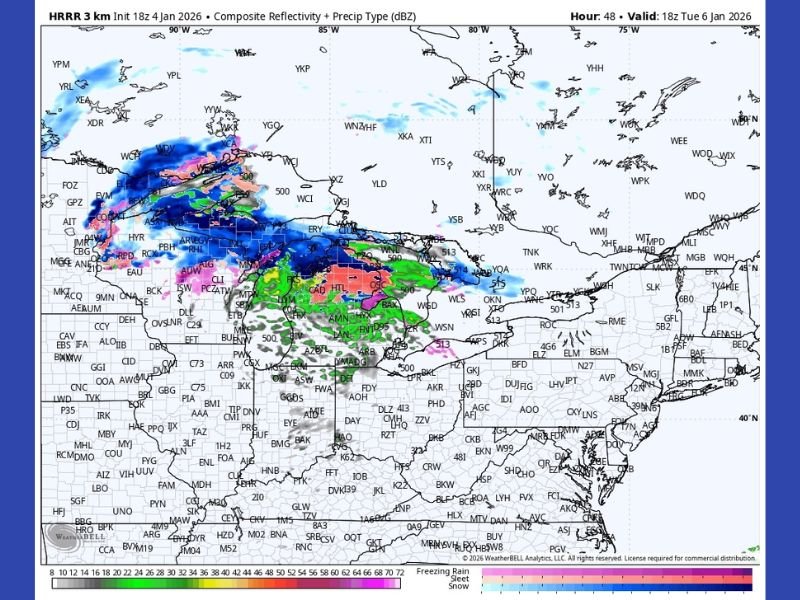
High-resolution forecast data indicates heavy snow on the northern side of the system, especially across parts of northern Minnesota, northern Wisconsin, and Michigan’s Upper Peninsula. Snowfall rates in these areas could be intense at times, quickly covering roads and reducing visibility during the overnight hours.
Farther south, snow is expected to transition into sleet and freezing rain, especially across southern Wisconsin, northern Illinois, lower Michigan, and parts of northern Ohio, where ice accretion could become a significant concern.
Freezing Rain Zone Raises Power Outage Risk
One of the most concerning aspects of this storm is the broad zone of freezing rain, shown clearly in forecast models across portions of Michigan, Ontario, northern Ohio, and western New York. Even light ice accumulation can create dangerous driving conditions, but thicker ice raises the possibility of tree damage and power outages.
Officials often warn that freezing rain is more dangerous than snow, as it is harder to treat and can develop rapidly with little warning.
Hazardous Travel Expected Across the Great Lakes
As precipitation types shift throughout the storm, road conditions may deteriorate quickly, especially during the Tuesday night and Wednesday morning commute window. Snow-covered highways, ice-glazed bridges, and reduced visibility are all expected, particularly near the Great Lakes shoreline, where lake-enhanced precipitation may locally worsen conditions.
Air travel may also be impacted, with delays possible at major regional airports as the storm passes through.
Storm Pushes East Toward New England
As the system moves east, New York and New England are expected to see increasing impacts, with snow to the north and a wintry mix farther south. Parts of Maine and upstate New York could see significant snow accumulation, while areas closer to the coast may deal with icy conditions before changing precipitation types.
The exact placement of the snow-to-ice line remains uncertain, which adds to the overall risk.
What Residents Should Know
This storm is shaping up to be more about impacts than totals, with dangerous travel, icy roads, and possible power issues being the primary concerns. Residents across the Great Lakes and Northeast are urged to monitor local forecasts closely, avoid unnecessary travel during peak conditions, and prepare for rapidly changing weather. For continued updates on major weather systems affecting the United States, stay with SaludaStandard-Sentinel.com.