Georgia, South Carolina, and North Carolina Face a Narrow Window for Sunday Morning Snow as Arctic Air Battles Coastal Moisture
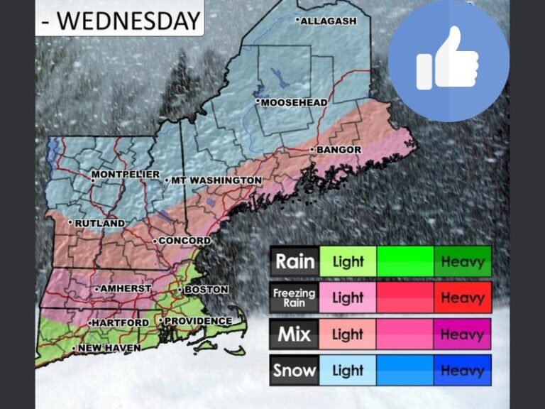
GEORGIA / SOUTH CAROLINA / NORTH CAROLINA — A delicate and time-sensitive winter setup is unfolding across parts of the Southeast late Saturday night into Sunday morning, with Georgia, South Carolina, and North Carolina all sitting in a narrow corridor where rain may briefly flip to snow before moisture exits the region. While this is not a major winter storm, the atmospheric ingredients are coming together just enough to spark localized snow bursts, especially around daybreak.
What’s Driving This Winter Setup
A strong cold front is pushing south and east overnight while upper-level energy slides across the Southeast. As rain develops after midnight, dynamic cooling becomes the key factor. If precipitation cools the air column down to around 32°F, rain can change over to snow during the final hours of available moisture.
This type of setup is often described as a “timing race” — cold air chasing moisture. If the cold air wins early enough, snowfall rates briefly increase. If it arrives too late, precipitation shuts off before meaningful accumulation can occur.
Best Time Window for Snow
The prime window for snow appears to be between roughly 7 AM and 10 AM Sunday. This is when colder air is deepest and lingering moisture may still be present. Any snow that develops during this time is expected to be brief but occasionally heavy, falling fast enough to coat grassy and elevated surfaces.
Favored Areas and State-by-State Breakdown
Georgia:
Central and portions of west-central Georgia, including areas near Macon and Americus, are under Winter Storm Warnings, where 1–3 inches of snow are possible in the most favorable zones. Surrounding counties under Winter Weather Advisories could see up to 1 inch, mainly on non-paved surfaces.
South Carolina:
Snow chances increase south and east of I-85, especially between Columbia and the Charlotte metro fringe. Not everyone will see snow, but isolated 1–2 inch pockets are possible if the rain-to-snow changeover happens early enough.
North Carolina:
Much of central and eastern North Carolina trends toward cold rain, though wet snowflakes may mix in late, especially northwest of Raleigh and Greensboro. Accumulation potential here remains low and spotty.
Why Impacts Stay Limited
Several factors are working against widespread accumulation:
- Daytime snowfall, leading to melting
- Marginal ground temperatures
- Short duration of snow bursts
That said, brief reductions in visibility and slick spots on bridges and overpasses are possible during heavier snow bursts.
Bottom Line
This is a low-impact but high-interest winter event for the Southeast. Many locations will see nothing more than cold rain, while a few lucky (or unlucky) spots may wake up to a quick dusting or isolated inch or two of snow. Roads should generally remain in good shape, but drivers during the morning hours should stay alert for localized slick conditions.
As always with Southeast winter systems, small timing changes can make a big difference, and updates will continue as the event unfolds. Stay weather-aware and keep checking Saluda Standard-Sentinel for the latest regional winter updates.