Florida Rain Pattern Intensifies Along I-4 Corridor From Tampa to Orlando as Storms Continue East Into Melbourne and Daytona Beach
FLORIDA — A persistent and uneven rain pattern is unfolding across central Florida, with the heaviest storms concentrating along and east of the Interstate 4 corridor from Tampa through Orlando and toward the east coast Monday evening.
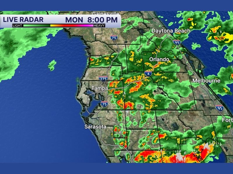
Live radar imagery shows scattered but intense pockets of rain and thunderstorms, creating a sharp divide between areas seeing heavy downpours and others remaining mostly dry.
Heaviest Rain Focused Along I-4 Corridor
The most consistent rainfall activity is developing along the I-4 corridor, stretching from Tampa through Orlando and continuing toward Melbourne and Daytona Beach. This region is seeing repeated bursts of moderate to heavy rain, with embedded thunderstorms producing localized downpours.
Radar data indicates clusters of storms moving across central Florida, with some areas experiencing steady rainfall while nearby locations remain largely unaffected. This pattern reflects the classic uneven distribution often seen in Florida weather systems.
Storm Activity Expands East Toward Coastal Areas
As the evening progresses, storm activity is pushing eastward, bringing rain into areas along the Atlantic coast. Cities such as Melbourne and Daytona Beach are beginning to see increasing coverage of showers and thunderstorms.
The eastward movement suggests that coastal communities may experience periods of heavier rain later in the evening, especially where storms organize and intensify.
Meanwhile, inland areas closer to Tampa and Sarasota continue to see scattered storms, though coverage varies significantly from one location to another.
Typical “Feast or Famine” Florida Weather Pattern
This weather setup highlights a common Florida scenario often described as “feast or famine,” where some areas receive heavy rain while others nearby see very little precipitation.
The uneven distribution is driven by localized storm development, influenced by sea breeze interactions, moisture levels, and subtle atmospheric boundaries.
As a result, rainfall totals can vary dramatically across short distances, making it difficult to predict exactly who will receive the heaviest rain.
Localized Downpours Could Cause Minor Impacts
While widespread severe weather is not indicated, localized heavy downpours could lead to temporary street flooding, reduced visibility, and slower travel conditions in affected areas.
Drivers along I-4 and surrounding roadways should be prepared for sudden changes in weather, including heavy rain bursts that can quickly reduce visibility. Lightning and brief gusty winds may also accompany stronger storm cells moving through the region.
Rain Coverage Likely to Remain Scattered Overnight
The current pattern suggests that rain and storm coverage will remain scattered through the night, with pockets of activity continuing to develop and move eastward.
Some areas may see repeated rounds of rain, while others could remain mostly dry, reinforcing the uneven nature of this setup.
Residents should remain alert for changing conditions, especially if traveling across central Florida during the evening hours.
Are you seeing heavy rain in your area or staying dry tonight? Share your local conditions with us at SaludaStandard-Sentinel.com and help others track this evolving Florida weather pattern.