Florida Braces for Another Sharp Cold Blast as EURO and GFS Models Signal Freezing Temperatures and Storms Next Week
FLORIDA — Another surge of cold air is expected to push into Florida next week, marking yet another abrupt temperature drop in an already volatile winter pattern. Forecast models indicate that a midweek cold front will usher in rain and storms before temperatures plunge sharply by Friday morning, with some northern and interior areas approaching freezing conditions.
Cold Air Set to Return After Midweek Front
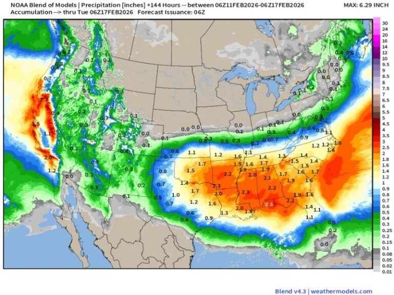
The latest runs of both the European (EURO) and Global Forecast System (GFS) models show strong agreement on a renewed invasion of cold air into the state. A midweek frontal boundary is expected to move south, bringing showers and isolated storms before allowing much colder air to settle in behind it. By Friday morning, temperatures across much of Florida are projected to fall rapidly, especially in northern and central regions.
Projected Temperatures Show Widespread Chill
Model guidance suggests upper 20s to low 30s across parts of North Florida, including the Panhandle and inland areas. Central Florida may dip into the mid to upper 30s, while South Florida is expected to cool into the low to mid-40s. Coastal locations may remain slightly warmer, but forecasters warn that wind and cloud cover could make conditions feel colder than the numbers suggest.
Why This Cold Outbreak Matters
Florida has already experienced multiple cold snaps this season, and forecasters describe the pattern as “yo-yo weather,” with dramatic swings between warm and cold conditions. This upcoming blast could again pose risks to sensitive plants, exposed pipes, and cold-blooded wildlife such as iguanas, which are known to become immobilized when temperatures fall into the 40s or below.
Rain and Storms Ahead of the Temperature Drop
Before the cold air arrives, the advancing front is expected to bring rain and embedded storms, particularly across northern and central Florida. While severe weather is not currently indicated, locally heavy rainfall and gusty winds remain possible as the system moves through.
Forecast Confidence Is Increasing
Meteorologists note that confidence in the cold outbreak is rising due to consistent signals across multiple model runs. While exact temperatures may still fluctuate, the overall message remains clear: another significant cold snap is coming, and residents should prepare accordingly.
What Floridians Should Do Now
Residents are advised to monitor updated forecasts over the coming days, especially those in northern and inland areas. Preparations may include protecting plants, checking heating systems, and being cautious during early morning travel when temperatures are lowest.
Wildlife officials also remind residents not to disturb cold-stunned animals, particularly iguanas, which often recover once temperatures rise. Are you ready for another cold round in Florida, or has this winter already worn you out? Share your thoughts and stay informed with trusted regional weather updates at SaludaStandard-Sentinel.com.