Flash Flood Risk Issued for Texas, Oklahoma, and Arkansas as Storm Systems Target Southern Plains This Week
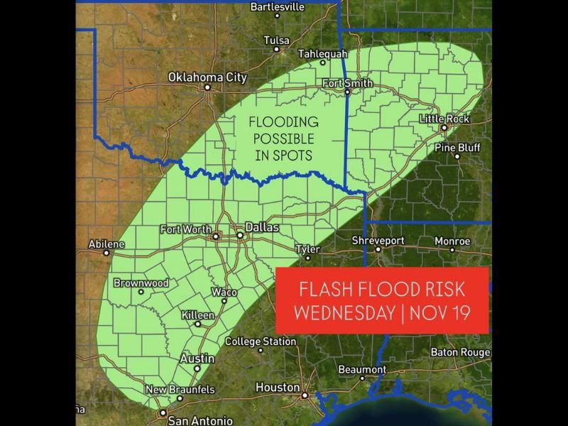
DALLAS, Texas — Meteorologists are warning of a growing flash flood risk across parts of Texas, Oklahoma, and Arkansas as a new storm system develops over the Southern Plains this week. The first in a series of weather disturbances is expected to arrive by Wednesday, November 19, bringing heavy rain, thunderstorms, and localized flooding to the region.
Active Weather Pattern Takes Shape Across the South
According to forecasters, an active weather pattern will begin to unfold midweek as warm, moist air from the Gulf of Mexico interacts with a slow-moving frontal boundary over the Southern Plains. The resulting setup could produce prolonged rainfall and isolated severe storms, especially from central Texas through eastern Oklahoma and into western Arkansas.
The National Weather Service (NWS) has identified a low flood risk zone for Wednesday that includes several major cities such as Dallas, Fort Worth, Austin, Waco, and Little Rock. This risk could increase as the system strengthens and moves eastward later in the week.
Areas Most at Risk
Weather maps show a broad zone of concern extending from San Antonio and Austin northward through Dallas–Fort Worth and Oklahoma City, then northeast toward Fort Smith and Little Rock.
Communities located along rivers and low-lying regions, particularly in north-central Texas and southeastern Oklahoma, may experience flash flooding if rainfall rates intensify.
Local forecasters note that this system will bring:
- 2 to 4 inches of rain, with isolated higher amounts possible.
- Localized flash flooding, especially in urban and poor drainage areas.
- Strong thunderstorms, with gusty winds and lightning possible in southern sections.
Rain and Storm Timeline
- Tuesday Night (Nov. 18): Cloud cover increases across Texas and Oklahoma as moisture builds.
- Wednesday (Nov. 19): Widespread rain and embedded storms move through the region. Flash flooding may begin in central Texas and southern Oklahoma.
- Thursday: The system tracks east into Arkansas, Louisiana, and Mississippi, potentially expanding the flood threat.
The heaviest rain totals are expected in a corridor stretching from Brownwood, TX through Dallas and Tyler, and extending northeast into Fort Smith, AR.
Travel and Safety Precautions
Officials urge residents to monitor weather alerts and avoid driving through flooded roadways. Even shallow water can quickly become dangerous, especially during nighttime hours when visibility is reduced.
Meteorologists also advise clearing drainage systems, securing outdoor items, and preparing for rapid weather changes through midweek.
“This system has the potential to produce excessive rainfall over a short period, leading to flash flooding in vulnerable areas,” NWS forecasters stated. “We expect additional updates as confidence grows in rainfall totals and storm intensity.”
Looking Ahead
After this first round of storms, additional weather systems are expected to follow over the weekend and early next week. Each could bring renewed rainfall to areas already saturated from Wednesday’s storm.
The Southern Plains will remain under heightened weather vigilance as the pattern continues into late November.
Stay with SaludaStandard-Sentinel.com for continued updates on flash flood alerts, severe weather watches, and safety information for communities across Texas, Oklahoma, and Arkansas.