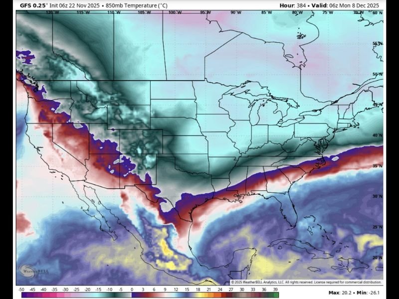
December 8 Forecast Models Warn Major Cold Blast Will Hit Texas, Louisiana, Mississippi, Alabama, Georgia, and the Carolinas
UNITED STATES — A powerful surge of cold air is expected to push deep into the South on December 8, with new forecast data showing a large portion of Texas, Louisiana, Mississippi, Alabama, Georgia, Tennessee, North Carolina, and South Carolina preparing for a significant temperature drop.
The intrusion of cold 850mb air — roughly 5,000 feet above the ground — is often a strong indicator that surface temperatures will crash rapidly.
Forecast Map Shows Deep Cold Penetrating the Southern U.S.
A newly issued forecast map from WeatherBell Analytics shows widespread blue and teal shading, signaling a major push of cold upper-air temperatures.
Meteorologists say this level of cold at 850mb often translates to substantially colder surface conditions, including freezing mornings and widespread frost potential across the South.
The setup suggests the South may experience one of its sharpest early-December cold intrusions so far this season.
Southern States Could Experience Freezing Conditions
Model projections indicate that December 8 could bring:
- Rapid overnight temperature drops
- Freezing levels reaching into North Texas
- Widespread frost across Mississippi, Alabama, and Tennessee
- A strong cold surge extending into Georgia and the Carolinas
- Wind chills far below normal for early December
This pattern typically develops when dense Arctic air slides southward behind a strengthened upper-air system.
Experts Highlight Strong Upper-Level Forcing
Meteorologists tracking long-range models say the cold air mass appears to be “sliding aggressively into the eastern half of the U.S.”
The 850mb layer, which dictates how cold air travels, shows a continuous southward push across the central and eastern states.
Forecasters note that when this much cold moves in at upper levels, surface temperatures can fall dramatically within hours.
What Residents in the South Should Prepare For
The incoming cold could lead to:
- Higher heating demand and increased utility use
- Morning vehicle-start issues
- Risk to outdoor pipes, gardens, and livestock
- A colder morning commute for millions
- Wind chills notably lower than forecast air temperatures
Forecasters emphasize that this system is not merely “passing by” the South — it is a direct cold-air intrusion with the potential for widespread impacts.
Meteorologists Mark December 8 as a Key Watch Date
Weather analysts say December 8 remains the key window to monitor as model consistency continues to hold.
If the cold fully mixes down to the surface, the South could experience temperatures well below seasonal averages, marking a notable shift into winter patterns.
If you live in any of the affected states or want to share how your community prepares for sudden cold snaps, join the conversation at SaludaStandard-Sentinel.com.