Dallas Fort Worth Texas Storms Expected Around 9–10 PM With Heavy Rain Overnight and Low Severe Risk
DALLAS-FORT WORTH, TEXAS — A new round of storms is expected to develop across the Metroplex Friday night, with the primary timing centered around 9 to 10 PM, bringing widespread rain and a low-end severe weather threat.
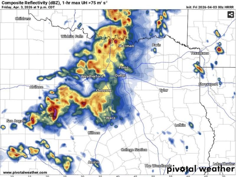
Forecast data shows a large cluster of storms organizing west of the Metroplex and pushing east toward cities including Weatherford, Dallas, Plano, Sherman, and Waco.
Storms Expected to Arrive Late Evening Across Metroplex
The latest model guidance highlights a developing line of storms moving into North Texas during the late evening hours.
The most likely arrival window for the Dallas-Fort Worth area is between 9 PM and 10 PM, with storms continuing to expand in coverage as they track northeast. Areas northwest of the Metroplex may see slightly stronger activity earlier in the evening before the system spreads across the region.
Heavy Rain Will Be the Main Impact Overnight
Unlike classic severe weather setups, this system is expected to produce widespread and persistent rainfall rather than intense severe storms.
Rain will likely continue on and off throughout the night, with multiple rounds possible as the system moves slowly through North Texas. Localized heavier pockets of rain could develop within the broader system, especially in areas from Weatherford through Dallas and up toward Sherman.
Severe Weather Risk Remains Low but Not Zero
While the overall severe threat is considered low, conditions are not completely stable. There is still a chance for a few stronger storms, particularly in areas northwest of the Metroplex where atmospheric conditions may support brief intensification.
The primary concerns in any stronger cells would be gusty winds and isolated thunderstorm activity, though widespread severe weather is not expected.
Storm Line Extends Across North and Central Texas
Radar projections show storms stretching from near San Angelo through Abilene, Weatherford, Dallas, and up toward Sherman, forming a broad southwest-to-northeast corridor of rain and thunderstorms. Cities including Cleburne, Waco, and Plano are also expected to be impacted as the system progresses eastward.
Residents Should Prepare for a Wet Night
With rainfall expected to continue through much of the night, residents across North Texas should plan for wet road conditions and reduced visibility during late evening and overnight travel.
Even without a major severe outbreak, lightning and brief heavy downpours could still create minor disruptions. If you’re seeing rain or storms in your area tonight, share your updates and stay connected with ongoing coverage on SaludaStandard-Sentinel.com.