Colorado, Wyoming, and Utah Brace for Dangerous Arctic Blast with 60 MPH Wind Gusts and Subzero Wind Chills
DENVER, COLORADO — A rapidly intensifying Arctic front is set to grip Colorado, Wyoming, and Utah with dangerously low wind chills and high winds late Sunday, prompting warnings from forecasters about extreme cold across the mountain west. Updated model data shows wind chills plunging below -20°F in higher elevations and gusts reaching up to 60 mph in exposed areas.
Severe Cold Expands Across the Mountain States
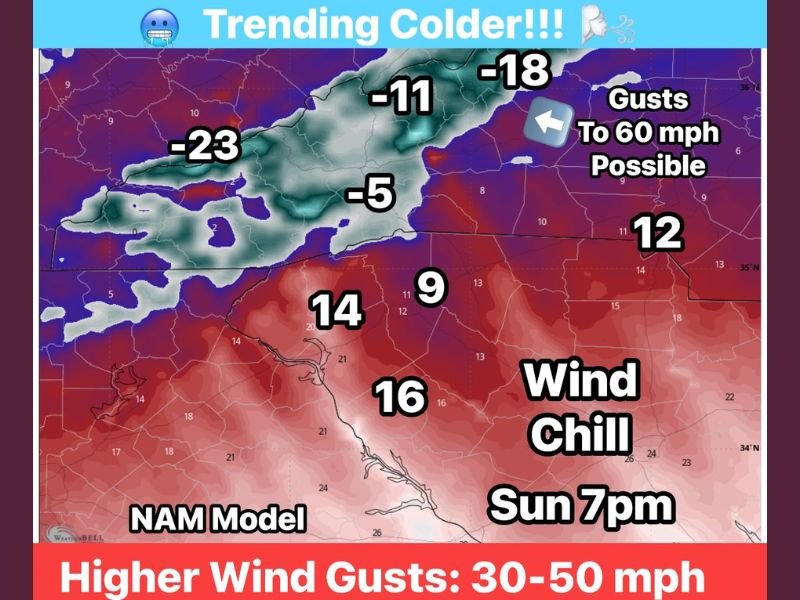
Meteorologists say the Arctic surge is strengthening as it sweeps south, bringing sustained winds of 40–50 mph and gusts up to 60 mph along ridgelines and passes. By Sunday evening, wind chill readings will drop to between -11°F and -23°F in the Rockies, with even lower values at altitudes above 4,500 feet.
“The new high-resolution data shows stronger winds and colder temperatures than initially forecast,” meteorologists noted. “This Arctic air mass is deepening, and we’re seeing the potential for life-threatening cold at higher elevations.”
Residents across northern Colorado, southern Wyoming, and northern Utah should expect rapidly deteriorating conditions late Sunday as the Arctic front sweeps through, driving temperatures into the single digits and below zero.
Winds Up to 60 MPH Could Cause Power Outages and Travel Disruptions
The National Weather Service has issued Wind Chill Warnings and High Wind Advisories across much of the region, warning that travel could become hazardous due to blowing snow and near-zero visibility in mountain corridors.
Winds between 40 and 60 mph could bring down tree limbs and power lines, potentially causing localized outages. Drivers, particularly those in high-profile vehicles, are urged to use caution on open highways and mountain roads.
“These aren’t ordinary winter winds,” one forecaster said. “These gusts can easily knock you off balance, and the wind chill will make it feel dangerously colder than it actually is.”
Wind Chill Readings Expected to Drop Below Zero
According to the NAM model, the coldest air will settle in by 7 p.m. Sunday, with projected wind chills of:
- -23°F in western Wyoming
- -18°F in northern Colorado
- -11°F to -5°F across mountain valleys in Utah
- Single digits in the lower elevations near the Colorado-New Mexico border
These conditions will make outdoor exposure extremely dangerous. Frostbite can occur on exposed skin in as little as 10 to 15 minutes when wind chills drop below -15°F.
Extreme Cold to Linger Through Monday Morning
The Arctic blast will hold firm into Monday morning, with temperatures struggling to rise above the teens in Colorado and Wyoming and the 20s in Utah. Wind speeds will slowly diminish through the afternoon, but bitter cold will persist across much of the region.
Meteorologists warn that this will be a short but intense Arctic outbreak, likely affecting power demand, travel, and agricultural operations through early week.
Residents are urged to avoid unnecessary travel, dress in multiple layers, and check on vulnerable neighbors and livestock as conditions worsen Sunday night.
For ongoing coverage and weather alerts across the region, visit SaludaStandard-Sentinel.com.