Colorado Mountains Brace For Multiple Rounds Of Heavy Snow Through Early Next Week
COLORADO — A series of storm systems is set to deliver continued mountain snowfall through Friday, followed by another significant round from Monday into Tuesday. Forecast data shows a stronger pattern developing for late next week, raising the potential for accumulating snow east of the Continental Divide as temperatures drop and moisture increases.
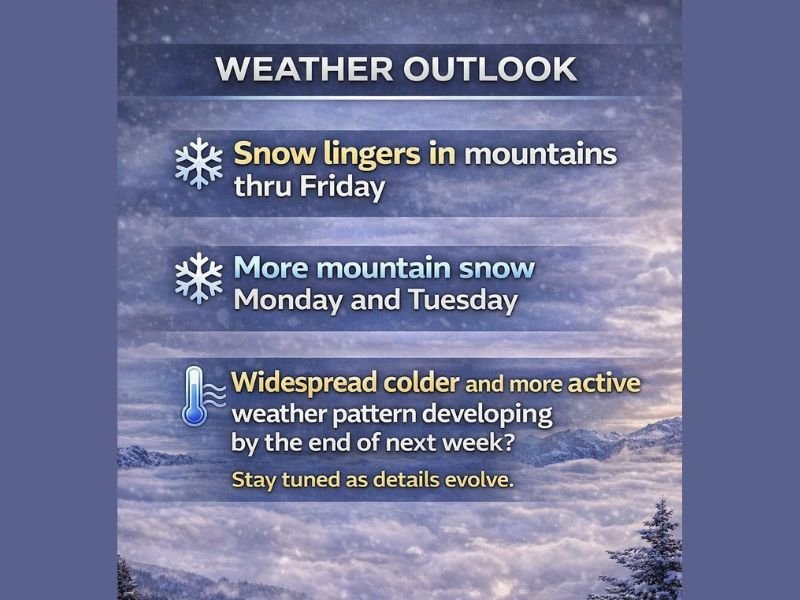
Snowfall Continues Through Friday
Meteorologists expect much-needed accumulation to persist across the central and northern Rockies through the end of the week. This includes the Steamboat, Breckenridge, Keystone, Winter Park, and Copper resort regions, where fresh powder has already been building. By Tuesday, portions of the San Juan Mountains and higher-elevation passes could be measuring snow in feet, a welcome boost for early-season ski conditions. Light to moderate snowfall will linger through Friday before tapering briefly late in the weekend.
Another Strong System Monday Into Tuesday
A new storm is projected to move in on Monday, bringing more widespread mountain snow. This next wave could enhance totals significantly, especially for resorts positioned north of Interstate 70. Snow ratios and timing will depend on how quickly colder air filters into the high country, but confidence remains high that early next week will produce substantial new accumulation. Forecasters say the Monday–Tuesday window is the second strong wave in a pattern likely to continue into mid-January.
Possible Snowfall East Of The Divide Late Next Week
Beyond the early-week system, medium-range models suggest a real chance for accumulating snow east of the Continental Divide between late Thursday and Friday next week. While timing discrepancies remain, model consistency over the past several days indicates this scenario should be monitored closely.
If moisture aligns with colder air, communities along Colorado’s Front Range could see their first meaningful snow in several weeks, with potential travel impacts during the Thursday-Friday period.
Resorts Positioned To Benefit Most
Current projections indicate that the San Juans, central mountains, and northern resort corridor will receive the highest totals through Tuesday. Lower elevations may see occasional light snow but will remain mostly unaffected outside of strong overnight temperature drops.
Forecasters will continue refining timing and accumulation ranges as the next two systems develop. Residents and travelers across Colorado are encouraged to stay updated on changing conditions. For more regional weather coverage and developing forecasts, visit SaludaStandard-Sentinel.com.