Colorado Foothills Explode With Lightning and 55 MPH Gusts as Storms Expand West of I-25 Into Larimer, Boulder and Park Counties Forcing Denver Flights Into Chaotic Patterns
COLORADO — Shower and thunderstorm activity is rapidly expanding across the Colorado foothills west of Interstate 25 and stretching up into southeast Wyoming right now, bringing intense and dangerous lightning, powerful wind gusts reaching up to 55 MPH, and widespread disruptions that are forcing inbound flights into Denver into chaotic holding patterns just to stay airborne safely. This is an active and rapidly evolving situation that is affecting communities, travelers, and airspace all at once.
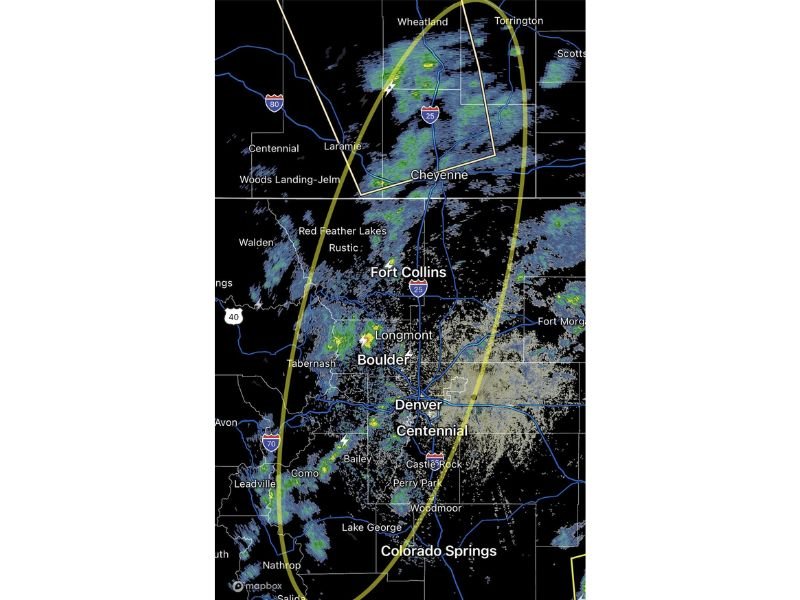
Lightning Going Absolutely Haywire Across Larimer, Boulder and Park Counties
Lightning activity is ramping up dramatically and intensifying across a wide swath of the Colorado Front Range foothills. Larimer County, Boulder County, and Park County are all seeing lightning strikes firing at an alarming rate as the storm complex expands and strengthens across the region.
Communities including Fort Collins, Boulder, Longmont, Red Feather Lakes, Rustic, and Bailey are all directly in the thick of this dangerous lightning environment right now. Anyone outdoors across these counties needs to get inside immediately. Lightning at this intensity kills without warning and there is absolutely no safe place to be outside during this level of electrical activity.
55 MPH Gusts Slamming Southeast Wyoming and Northern Colorado
Wind gusts reaching up to 55 MPH are hammering southeast Wyoming and pushing south into northern Colorado communities. Cheyenne, Laramie, and surrounding areas are getting battered by these powerful gusts that are strong enough to knock down trees, scatter debris, and make driving on exposed highways genuinely dangerous.
Drivers along Interstate 25 and Interstate 80 through this corridor should expect sudden and violent wind gusts that can push vehicles out of their lanes without warning. Slow down, grip the wheel firmly, and pull off the road if gusts become unmanageable.
Denver Flights Forced Into Sky Donuts to Survive This Storm
Perhaps the most striking consequence of this storm system is what is happening thousands of feet above the ground. According to FlightAware data, multiple inbound flights into Denver are currently flying holding patterns, circling repeatedly in the sky to avoid the dangerous wind shear and navigate around the expanding storm complex.
Travelers flying into Denver International Airport should expect significant delays as aircraft are forced to burn fuel waiting for safer approach windows. Check your flight status immediately and contact your airline for updates before heading to the airport.
The storm system is continuing to expand and intensify, and conditions across the Colorado foothills and southeast Wyoming are expected to remain dangerous and active through the evening hours.
Stay weather aware and check your flight status at SaludaStandard-Sentinel.com.