Cold Weather Advisory Issued for Florida as Temperatures Drop — and Iguanas Could Fall from Trees
FLORIDA — The National Weather Service has issued a Cold Weather Advisory across Florida tonight as temperatures plunge well below normal for mid-November, with wind chills dipping into the 20s and 30s in parts of the state.
Meteorologists say some northern and inland regions could feel like the upper teens by early Tuesday morning. The extreme cold has also triggered an unusual but familiar Florida alert — a warning for “falling iguanas” as the state’s reptile population reacts to the frigid temperatures.
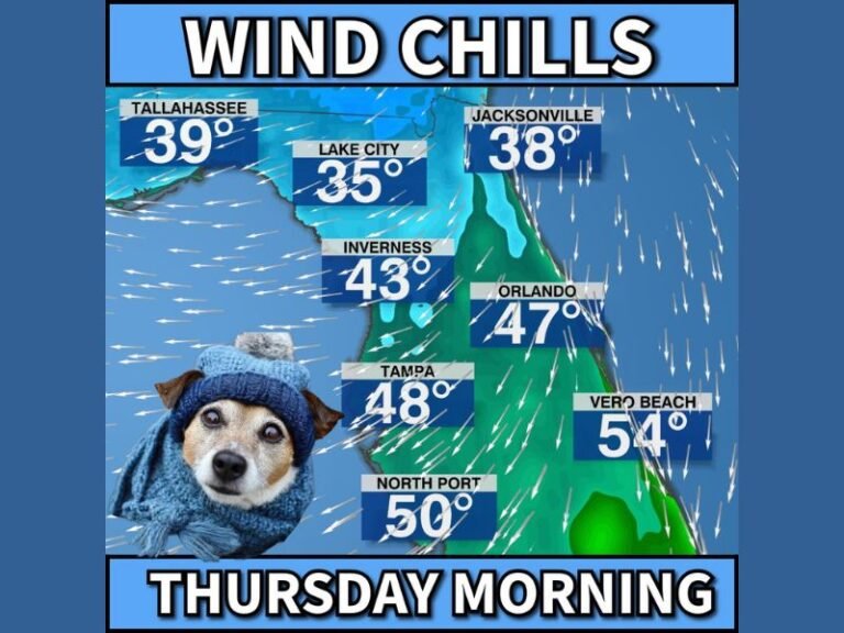
Wind Chills and Freezing Air Spread Across the State
According to the latest update from Meteorologist Chris Nunley, cold air is sweeping across the state from the Panhandle to South Florida. Residents in Tallahassee, Gainesville, Orlando, and Tampa are expected to experience overnight lows in the upper 20s and 30s, while coastal areas and southern cities such as Miami and Palm Bay will drop into the 40s.
Strong winds will make the chill even more biting. The National Weather Service warns that wind chills could reach the upper teens in northern counties and the low 30s in central Florida, creating conditions that are both rare and potentially hazardous for residents and wildlife alike.
‘Falling Iguanas’ Alert Returns
The cold snap has also prompted a seasonal warning for Floridians to watch out for falling iguanas. These large lizards, common in South Florida, become immobilized when temperatures drop below 40°F.
“When it gets this cold, iguanas can lose their grip and literally fall from trees,” meteorologists explained. “They’re not dead — just stunned by the cold.”
Experts urge residents not to disturb the reptiles, as they typically recover once temperatures rise again. The advisory, which has gained national attention in recent years, serves as a reminder of Florida’s unique ecosystem and how it reacts to sharp temperature swings.
Wildlife and Safety Precautions
Authorities are reminding residents to protect outdoor pets, cover plants, and check on vulnerable neighbors as the cold front settles in. Those venturing outside are urged to dress warmly, especially during the early morning hours when wind chills will be at their lowest.
Farmers across the state are also taking precautions to shield crops from frost damage, particularly in central Florida’s agricultural belt.
The Florida Fish and Wildlife Conservation Commission added that drivers should use caution on roadways where immobilized iguanas or other wildlife could appear overnight or early in the morning.
Rare Early-Season Chill
This week’s cold front marks one of the earliest significant cold events of the season for Florida. Meteorologists say the Arctic air mass responsible for the drop in temperature is the same system that has brought snowfall to parts of the Carolinas, Georgia, and Tennessee.
The cold conditions are expected to linger through midweek before a gradual warm-up returns by Friday.
Residents can track temperature updates, wind chill maps, and safety alerts through the National Weather Service or local county emergency management pages.
For ongoing weather updates and statewide advisories, visit SaludaStandard-Sentinel.com.