Cold Front Sweeping From Iowa Into Missouri Could Trigger Overnight Storms Across Illinois Between 2 AM and 7 AM Saturday
ILLINOIS — A developing weather system pushing out of the Midwest could bring overnight thunderstorms into central Illinois as a cold front advances southeast from Iowa into Missouri. Meteorologists say storms already moving through eastern Missouri Friday evening may reach Illinois later tonight, with the most active window expected early Saturday morning.
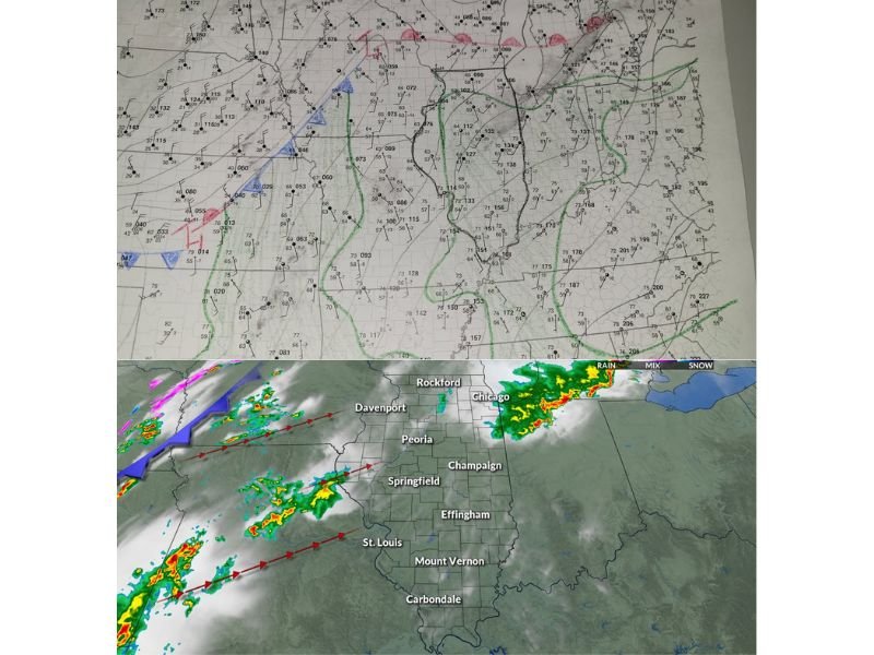
Weather analysis around 7 PM Friday shows the cold front advancing across Iowa and northwest Missouri, with warmer and more humid air positioned ahead of the system across parts of the Midwest. Dew points across eastern Kansas and Oklahoma were in the 60s, helping create moderate atmospheric instability that supports thunderstorm development.
Although some slightly drier air was present across central and eastern Missouri, moisture increases again across central Illinois, which could allow storms to strengthen slightly as they move east.
Storms Expected to Move From Missouri Into Illinois Late Tonight
A batch of thunderstorms currently tracking through eastern Missouri is expected to move toward central Illinois after 9 PM Friday evening.
Forecasters say these initial storms are not expected to be severe, but conditions may allow them to intensify somewhat as they encounter richer moisture across Illinois.
Higher dew points across central Illinois could provide the additional fuel needed for storms to maintain strength as they continue eastward overnight.
Meteorologists caution that while severe weather is not guaranteed, the environment could still support stronger thunderstorms if storm cells organize properly.
Second Round of Storms May Arrive After Midnight
The next potential wave of storms is expected to develop along and behind the advancing cold front, forming a broken line of thunderstorms that could push toward Illinois later in the night.
Forecast models suggest this line may reach central Illinois sometime after midnight, though the storms could struggle initially due to lower dew points over parts of Missouri.
If the storms manage to survive that drier air and reach the more humid environment over Illinois, forecasters say they could briefly intensify before weakening again.
This setup makes the overnight hours particularly important for monitoring storm development across the region.
Main Window for Storm Activity Between 2 AM and 7 AM
Current timing projections indicate that the primary window for storms in central Illinois will occur between roughly 2 AM and 7 AM Saturday morning.
Radar timing estimates suggest storms may begin reaching western portions of the region shortly after midnight, gradually pushing eastward through the early morning hours.
Cities including Peoria, Bloomington, Lincoln, and Pontiac could see storms during this early morning period as the system moves across the state.
While the overall severe threat appears limited at this time, residents are encouraged to remain weather aware overnight as conditions could change.
Residents Urged to Monitor Overnight Weather Alerts
Because the storms are expected to arrive during overnight hours when many people are sleeping, meteorologists emphasize the importance of having weather alerts enabled on mobile devices.
Storms moving through the region may produce brief heavy rainfall, lightning, and gusty winds, even if they remain below severe levels.
Officials recommend monitoring local forecasts and ensuring that weather notifications are active in case stronger storms develop overnight.
Stay with Saluda Standard-Sentinel for continuing updates as this Midwest storm system progresses through Illinois and neighboring states heading into Saturday morning.