Cold Front Brings Morning Showers to North Carolina With Cooler 50s and 60s Before Skies Gradually Clear From Northwest to Southeast
NORTH CAROLINA — A passing cold front is bringing scattered rain showers across the state Wednesday, especially through central and southern areas, before conditions gradually clear later in the day from northwest to southeast.
Forecasters indicate a more active start to the day compared to earlier in the week. Showers are moving through during the morning hours, with the highest rain coverage focused across central and southern North Carolina. While rain will not be widespread everywhere, residents in the southern half of the state can expect more consistent precipitation through midday.
Rain Shifts South as Clearing Begins
As the disturbance pushes eastward, rainfall will steadily move south through the afternoon. Skies will begin clearing first across the northwestern Piedmont and mountain regions, then gradually improve toward the southeast by evening.
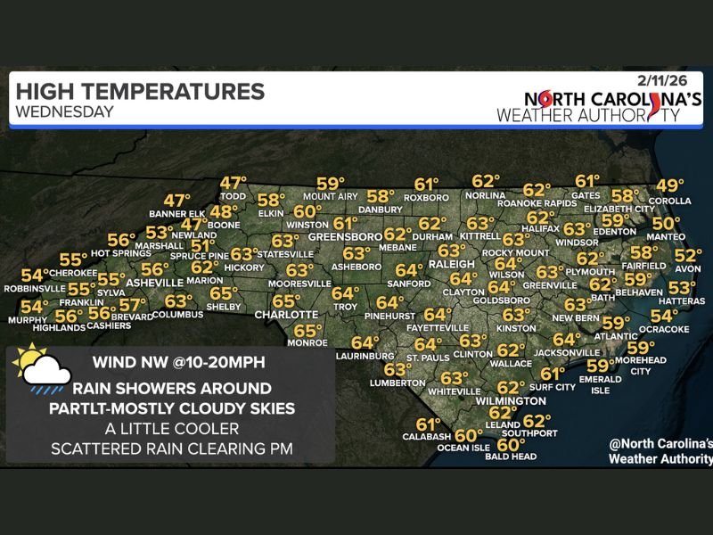
Cloud cover will remain part to mostly cloudy for much of the day, particularly in areas still dealing with lingering showers. By late afternoon and evening, conditions should trend drier statewide. Winds will shift out of the northwest at 10 to 20 mph, reinforcing cooler air behind the front.
Cooler Highs Across the State
High temperatures Wednesday will run cooler compared to recent warm days, generally landing in the 50s across the mountains and low to mid-60s across the Piedmont and coastal plain.
Forecast highs include:
- Upper 40s to low 50s in higher mountain elevations such as Boone and Banner Elk
- Mid to upper 50s in western cities like Asheville
- Lower 60s in Greensboro, Durham, and Raleigh
- Mid-60s in Charlotte, Fayetteville, and Goldsboro
- Upper 50s to near 60 along portions of the Outer Banks and immediate coast
The farther south you are in the state, the greater the likelihood of seeing measurable rainfall before clearing begins.
No Severe Weather Expected
Despite the unsettled conditions, this system is not expected to produce severe weather. Rainfall amounts should remain light to moderate and scattered in nature rather than widespread and heavy. Roadways could be damp during the morning commute, particularly in central and southern counties, so drivers are encouraged to allow extra travel time.
Looking Ahead
Once this cold front moves offshore, drier conditions are expected to return. While temperatures are slightly cooler today, no significant cold blast is associated with this system.
Residents are encouraged to keep rain gear handy through the morning and monitor updated forecasts as conditions improve later today. For continuing coverage of North Carolina weather and regional updates, visit SaludaStandard-Sentinel.com.