“Barney Invasion” Arctic Blast May Drive Temperatures 20+ Degrees Below Normal Across the Southeast and Florida Next Weekend
UNITED STATES — A significant surge of arctic air is increasingly likely to push into the Southeastern United States and Florida next week, bringing temperatures 20 or more degrees colder than normal in several areas and raising the possibility of the first freeze of the season for parts of Florida, according to emerging model trends.
The unusually cold setup—humorously dubbed a “Barney invasion” due to the deep purple shading on temperature anomaly maps—signals a sharp pattern change that could impact millions across the region.
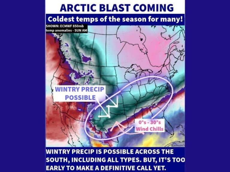
What the Anomaly Map Is Showing
The temperature anomaly map highlights widespread deep purple shading across the Southeast, including Georgia, Alabama, South Carolina, North Carolina, and much of Florida, indicating temperatures running well below seasonal averages.
Meteorologically, purple anomalies of this magnitude typically reflect strong arctic air masses spilling southward behind one or more reinforcing cold fronts. Forecast guidance suggests some locations could experience conditions more typical of mid-winter rather than early season.
Multiple Cold Fronts Set to Reinforce the Chill
Forecast discussions indicate that a couple of cold fronts may move through the region in quick succession, each reinforcing the cold air already in place.
This type of pattern limits daytime recovery and allows overnight lows to fall more efficiently, especially in inland and rural areas. The rapid drop has been compared to temperatures “falling like iguanas,” a reference to how cold snaps impact wildlife in Florida.
Florida Freeze and Even Snow Being Monitored
While Florida is no stranger to brief cold shots, this setup raises the possibility of the first freeze for some inland parts of the Sunshine State, particularly in north and central Florida.
Some long-range model solutions have even teased the idea of Florida snow, though forecasters stress that this remains highly uncertain and far from locked in. Any winter precipitation would require precise timing and moisture alignment, which may change multiple times before the event.
Why Confidence Is Growing—but Details Are Not Final
Confidence is increasing in the overall cold pattern, but specific temperatures and impacts remain fluid. With the event still several days away, model guidance is expected to shift as additional atmospheric data is sampled. This is typical of arctic intrusions, where small changes in timing or frontal placement can significantly alter who sees the coldest conditions.
What Residents Across the Southeast Should Do Now
Residents across the Southeast and Florida should begin monitoring updated forecasts closely, especially those with sensitive plants, pets, or outdoor plumbing.
While the exact outcome may evolve, the signal for a sharp and widespread cooldown next weekend is strong, and preparations for unusually cold weather may soon be necessary. Stay tuned for continued updates, freeze timing refinements, and any winter weather potential by following ongoing coverage at SaludaStandard-Sentinel.com.