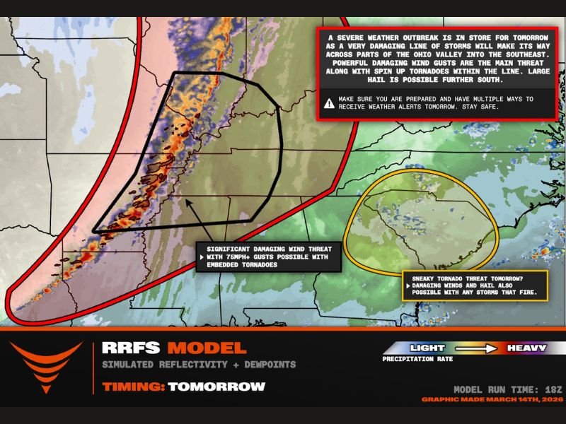
Arkansas, Mississippi, Tennessee and Kentucky Brace for Significant Tornado Threat and 75+ MPH Winds Sunday Evening Through Midnight
ARKANSAS, MISSISSIPPI, TENNESSEE AND KENTUCKY — Meteorologists are warning of a potentially dangerous severe weather outbreak expected to develop Sunday afternoon and continue into the overnight hours across portions of the Mid-South and lower Ohio Valley.
Forecast models indicate that powerful thunderstorms capable of producing significant tornadoes, destructive wind gusts, and large hail could form across several states as a strong storm system moves through the region. The greatest concern stretches from eastern Arkansas through northern Mississippi and into western Tennessee and Kentucky, with the risk area extending northward toward southern Illinois and parts of Indiana.
Highest Tornado Threat From Arkansas Into Tennessee and Kentucky
Forecasters say the most favorable environment for strong tornadoes may develop during the late afternoon and evening hours. Areas including Memphis, Paducah, and Nashville are positioned within the corridor where atmospheric conditions could support rotating supercell thunderstorms capable of producing tornadoes.
Meteorologists note that the atmosphere is expected to become increasingly unstable as warm, moisture-rich air surges northward ahead of the approaching storm system. This unstable air combined with strong wind shear in the atmosphere could allow storms to intensify quickly and begin rotating.
Severe Storm Window Expected From Late Afternoon Through Midnight
The most dangerous period for severe weather appears to be between 4 p.m. and midnight, when thunderstorms could rapidly organize into powerful storm cells or lines. During this time, storms may produce tornadoes along with damaging straight-line winds potentially exceeding 75 miles per hour.
These types of wind gusts can cause widespread tree damage and power outages even outside of tornadoes. Embedded tornadoes within larger storm lines are also possible as the storms move northeast across the region.
Damaging Wind Threat Could Be Widespread
While tornadoes are a primary concern, meteorologists emphasize that damaging winds may ultimately impact the largest number of communities. Strong thunderstorm clusters could form into a long line capable of sweeping across parts of the Ohio Valley and southeastern United States.
Within these lines of storms, powerful wind gusts may cause structural damage, topple trees, and knock out power to thousands of residents. Some storms farther south may also produce large hail, particularly during the earlier stages of development before storms merge into a line.
Residents Urged to Prepare Ahead of Severe Weather
With storms expected to intensify quickly during the late afternoon and evening hours, officials are encouraging residents across the risk area to prepare in advance.
Having multiple ways to receive weather alerts is especially important during severe weather events where tornado warnings may be issued with little notice. Weather radios, smartphone alerts, and local broadcast stations are among the most reliable ways to receive warnings.
Emergency managers also recommend identifying safe shelter locations within homes or buildings in case tornado warnings are issued. Meteorologists say storm-chasing teams and weather experts will be monitoring the situation closely throughout the afternoon as conditions become more favorable for severe weather development.
Residents across the region should continue monitoring forecast updates and remain prepared for rapidly changing weather conditions Sunday afternoon and night. If severe storms develop in your area, share your experience and local updates with the newsroom at SaludaStandard-Sentinel.com so others across the country can stay informed about this developing severe weather threat.