Arkansas, Louisiana and Texas at Center of Potential Late-February Winter Storm as Euro Model Hints at ArkLaTex Track
ARKANSAS — A new late-February model run is catching the attention of weather watchers across the South-Central United States, showing the potential setup for what meteorologists often call an “ArkLaTex storm” — a system that could impact parts of Arkansas, Louisiana and Texas around February 27.
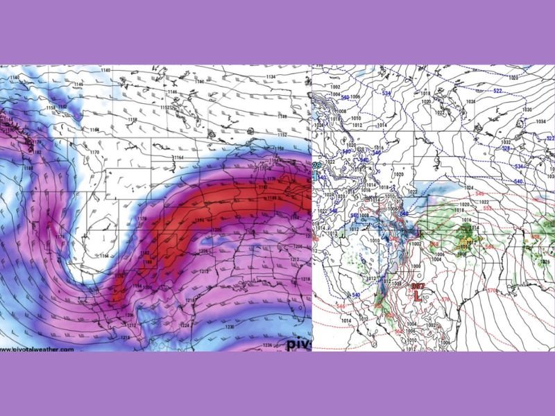
The latest European (Euro) model guidance highlights a developing surface low near the ArkLaTex region — where the three states meet — before the system lifts northward. While it is still several days out and subject to change, the overall jet stream configuration suggests a pattern capable of supporting a more organized storm system.
Jet Stream Setup Shows Strong Energy
Upper-level maps indicate a pronounced dip in the jet stream across the western United States, with strong southwest flow extending into the Southern Plains and Lower Mississippi Valley. That kind of configuration can help storms intensify as they move from the Southern Plains toward the Mid-South.
In the current projection, the surface low appears near the ArkLaTex region before tracking north. That “jump” toward the tri-state border and subsequent northward turn is a classic storm evolution in this part of the country.
Cold Air Will Determine Snow Potential
While the storm signal is there, one key factor remains: cold air placement.
For snow lovers, ArkLaTex-origin storms can be some of the most productive winter setups — but only if temperatures are cold enough. If sufficient cold air is in place north and northwest of the track, areas in Arkansas and possibly surrounding states could see wintry precipitation.
If temperatures trend warmer, the system would likely bring mainly rain and perhaps thunderstorms. At this stage, it is too early to lock in specifics. Model runs beyond a week can shift in strength and track. Small changes in storm position could significantly alter precipitation type and totals.
Still Too Early for Exact Impacts
It is important to emphasize that this is a long-range projection. Forecast confidence decreases the farther out in time a model looks. However, the broader pattern does support an active storm track across the southern tier of the country late in the month. Residents across Arkansas, northern Louisiana and eastern Texas should monitor updated forecasts over the coming days as the system draws closer.
Even if the storm ultimately tracks differently, the evolving jet stream pattern suggests that the final week of February may not go quietly. For continued updates on developing weather patterns and potential impacts across the region, stay connected with SaludaStandard-Sentinel.com.