Arctic Cold Front to Bring 40–50 Degree Temperature Crash, Dangerous Wind Chills and Rapid Freeze Across Indiana Sunday Night
INDIANA — A powerful arctic cold front is expected to sweep across Indiana Sunday night, causing temperatures to drop from the 60s into the 20s and 10s within hours, creating hazardous travel conditions and dangerously cold wind chills by Monday morning.
Temperatures Crash From 60s to 20s and 10s in Just a Few Hours
Forecasters say the dramatic temperature plunge will begin around 8 p.m. in western Indiana, racing eastward and reaching the eastern part of the state by midnight. Once the front moves through, temperatures will fall sharply, and any wet surfaces will freeze rapidly, increasing the risk of icy roads and sidewalks.
Cities including Evansville, Terre Haute, Bloomington, Indianapolis, and South Bend are all expected to experience rapid cooling and deteriorating surface conditions.
Break Between Rain and the Arctic Front May Help, But Slick Spots Still Likely
Meteorologists note that timing may allow some surfaces to dry before the cold air arrives, but residents should still expect isolated icy patches, especially on untreated roads, bridges, porches, and sidewalks. Even a brief window of freezing temperatures after rainfall can create high-impact flash-freeze hazards. The sharp temperature drop will be accompanied by gusty winds, making conditions feel even colder overnight.
Wind Chills Drop Below Zero in Northwest Indiana
By 7 a.m. Monday, wind chills in northwest Indiana are expected to fall well below zero, while most other parts of the state will experience single-digit wind chill readings. Forecasters warn that these conditions may be dangerous for anyone spending extended time outdoors without proper winter protection. The rapid cooling and strong winds may also lead to minor tree limb damage and scattered slick travel during the Monday morning commute.
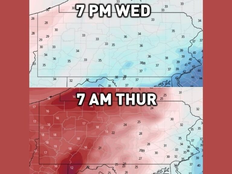
State Weather Map Highlights Extreme Contrast
Weather graphics show a stark contrast between 60-degree temperatures ahead of the front and 20-degree air surging in behind it. With winds increasing and temperatures falling faster than road surfaces can adjust, even normally safe routes may turn slippery with little warning.
Residents across Indiana are urged to prepare for a fast-changing atmosphere and share local weather conditions at SaludaStandard-Sentinel.com throughout the event.