Arctic Blast Drops “Feels Like” Temperatures Into the 20s Across the Southeast as Florida Stays Warm Ahead of Sharp Nighttime Cooldown
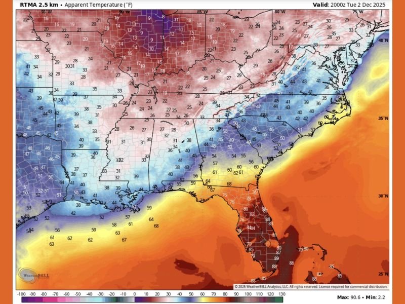
BIRMINGHAM, AL — A powerful surge of Arctic air is sweeping through the Southeast United States, plunging apparent temperatures into the 20s and 30s across Mississippi, Alabama, Georgia, and the Carolinas on Tuesday evening. The sudden temperature drop is expected to leave many residents facing bitterly cold conditions as they head home from work, while Florida remains unusually warm — for now.
Wind Chills Fall Below Freezing Across Multiple States
The latest high-resolution weather data shows that a cold air mass moving south from the Tennessee Valley and Midwest is generating widespread “feels like” temperatures in the 20s to low 30s across much of the Southeast.
According to WeatherBell Analytics, states such as Alabama, Mississippi, and Georgia are seeing apparent temperatures dip into the mid-20s, with the coldest readings near northern Alabama and central Tennessee where wind chills are in the teens.
In contrast, Florida remains in the mid-80s, creating a striking temperature divide across the region. Meteorologists say the warm air across the peninsula will not last long, as the advancing front will push southward overnight, cooling areas like Tallahassee and Gainesville by Wednesday morning.
Cold Front Brings Sharp Temperature Shock
Residents across the Deep South who stepped out of offices and schools late Tuesday felt the chill instantly. Many reported that what felt like a mild afternoon quickly turned into a “shock of winter air,” with strong northwest winds making the cold feel even more intense.
By 5 p.m., areas such as Birmingham, Jackson, and Montgomery had wind chills hovering near freezing. The sudden change follows several days of relatively mild weather, amplifying the shock factor of the Arctic blast.
“People walking out of their offices this evening were met with wind chills cold enough to freeze your motivation,” one weather observer joked, warning residents to dress warmly for evening commutes.
Florida Enjoys Warmth Briefly Before Cold Moves In
Meanwhile, Florida’s peninsula remains the only pocket of warmth in the region, with afternoon highs soaring to the mid-80s in Orlando, Tampa, and Miami. The warmth, however, will be short-lived. By late Tuesday night, colder air is expected to reach North Florida, dropping overnight lows into the 40s and 50s before spreading southward through Wednesday.
Meteorologists note that the sharp contrast — 80s in Florida and 20s in neighboring Alabama — highlights the strength of this early-season Arctic front.
Safety Tips as Cold Expands Overnight
Officials across the Southeast are urging residents to dress in layers, limit outdoor exposure, and ensure that pets and vulnerable individuals are kept warm.
For commuters, black ice and frost could develop on rural roads by early morning, especially in Mississippi and northern Alabama where temperatures will dip below freezing.
Those in Northwest Florida and southern Alabama are encouraged to secure outdoor items as the incoming cold front brings strong gusty winds overnight.
Arctic Air to Linger Through Midweek
Forecasters expect the cold pattern to persist through at least Thursday morning before gradual warming returns heading into the weekend. Another reinforcing front may arrive by Friday, keeping temperatures below seasonal averages across the Southeast.
If you’re braving the cold tonight, bundle up — this Arctic front marks the start of a much colder December stretch across the Deep South.
Stay tuned for continuing weather coverage and community updates at SaludaStandard-Sentinel.com.