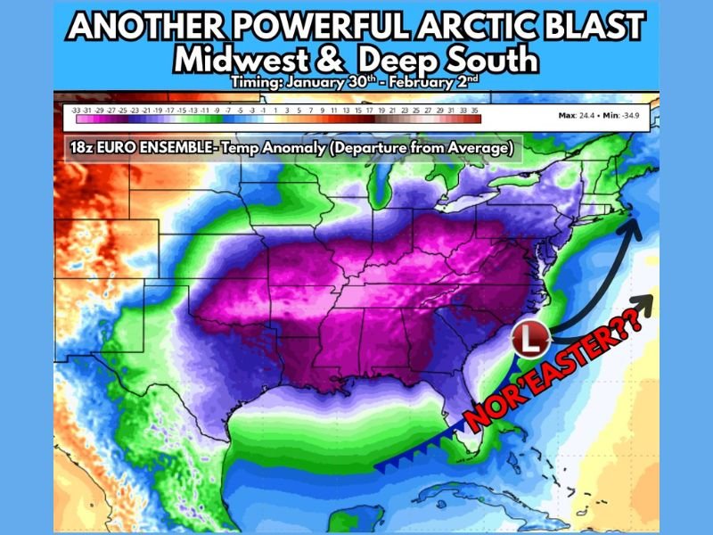
Another Powerful Arctic Blast Set to Grip the Midwest and Deep South With Temperatures 20–30 Degrees Below Average
UNITED STATES — Another significant Arctic blast is expected to move into the Midwest before spreading into the Deep South later this week, bringing dangerously cold temperatures, renewed winter hazards, and the potential for another major storm system along the East Coast. Forecast guidance shows temperatures plunging 20 to 30 degrees below seasonal averages, with the cold intensified by widespread snow and ice already covering much of the Central and Eastern United States.
This developing pattern raises concerns not only for prolonged cold exposure, but also for infrastructure strain, icy travel conditions, and possible coastal storm impacts as the cold air becomes firmly entrenched.
Arctic Air to Spread South After Midwest Arrival
The cold air mass is expected to first settle over the Midwest, where temperatures will drop sharply as Arctic air surges southward. From there, the cold will expand into the Deep South, reaching areas that have already endured recent winter storms.
Because much of the region remains covered by snow and ice, daytime temperatures may struggle to recover, allowing the cold to linger longer than usual. Overnight lows are expected to fall well below normal, increasing the risk of hypothermia, frozen pipes, and power demand spikes.
Snow and Ice Pack Will Intensify the Cold
Forecasters note that the existing snow and ice pack across the Central and Eastern U.S. will play a major role in amplifying the cold. Snow-covered ground reflects sunlight and limits daytime warming, keeping temperatures suppressed even during peak afternoon hours.
This setup could make this Arctic blast feel colder than previous outbreaks, particularly in areas that have not fully thawed from earlier winter events. Wind chills may fall to dangerous levels, especially during overnight and early morning hours.
Pattern Favors Possible Nor’easter Along East Coast
With cold air firmly in place and an active storm pattern developing, meteorologists are closely watching the potential for a Nor’easter to form along the East Coast. While the exact track and intensity are not yet locked in, the current setup is considered favorable for a coastal storm capable of producing snow, ice, or strong winds.
Any storm developing along the coast would interact with the entrenched Arctic air, raising the risk for significant winter impacts, especially in areas already vulnerable from earlier storms.
Timing and What to Expect
The coldest period is expected between January 30 and February 2, with temperatures remaining well below average for several days. Even regions accustomed to winter cold could see prolonged subfreezing conditions, while southern areas may experience some of their coldest temperatures of the season.
Residents are urged to prepare now by checking heating systems, protecting exposed pipes, and limiting outdoor exposure during the coldest periods. Travel disruptions and icy conditions may redevelop quickly as temperatures drop.
Are you preparing for another surge of Arctic cold? Share how conditions are changing in your area and stay connected with SaludaStandard-Sentinel.com for continued updates as this powerful winter pattern unfolds.