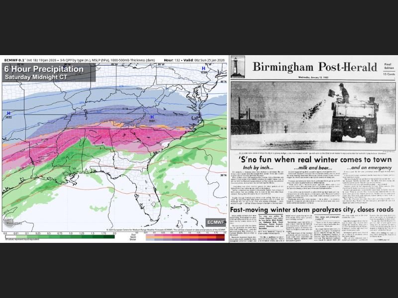
Alabama Ice Storm Risk Revives Memories of 1982 as Models Signal Potentially Significant Freezing Rain This Weekend
ALABAMA — As forecast models continue to signal the potential for significant freezing rain across northern Alabama this weekend, meteorologists are increasingly drawing comparisons to some of the state’s most destructive ice storms, including the infamous January 1982 event.
While it is still too early to determine whether this system will reach historic levels, the pattern unfolding has raised concern among forecasters who study past cold-weather disasters in the Deep South.
Why Alabama’s Ice Storm History Matters
Alabama does not experience ice storms frequently, but when they occur, the impacts can be catastrophic. The last major ice storm in the state occurred February 1–2, 1996, when some areas recorded up to one inch of ice accumulation on trees, power lines, and roadways.
Even more severe was the January 1982 ice storm, widely considered the most destructive winter weather event in modern Alabama history.
The January 1982 Ice Storm: A Benchmark Event
In early January 1982, an extended stretch of bitter cold set the stage for disaster. Birmingham plunged to –1°F on January 11, an exceptionally rare temperature for the region. When moisture arrived the following day, it fell almost entirely as freezing rain.
The precipitation arrived nearly eight hours earlier than forecast, rapidly turning roads into sheets of ice. Thousands of motorists were stranded, abandoning vehicles and walking home or seeking shelter. Brookwood Village Mall became a massive emergency shelter, while the Birmingham Police Department was overwhelmed by the sheer volume of crashes and calls.
Widespread Damage and Long-Term Impacts
As freezing rain continued through the night, ice coated every exposed surface. Trees snapped under the weight, pulling down power lines and plunging up to 750,000 Alabamians into darkness.
A state of emergency was declared, National Guard armories were opened as shelters, and some residents went weeks without power. The storm ultimately claimed 20 lives, injured more than 300 people, and caused an estimated $78 million in damage, a staggering figure for the time.
How This Weekend’s Setup Compares
Current forecasts suggest one key difference: temperatures will be in the 50s Wednesday through Friday ahead of the storm, meaning infrastructure will not be as deeply frozen at the onset as it was in 1982. That factor alone could reduce the severity of damage.
However, forecast models continue to advertise the potential for significant ice accumulation over northern Alabama, especially if surface temperatures fall faster than expected once precipitation begins.
Uncertainty Remains, but Signals Are Concerning
Meteorologists caution that it is too early to say whether this weekend’s storm will approach the scale of 1982, but the signal for impactful icing cannot be ignored. Even moderate ice accumulation in Alabama can result in dangerous travel conditions, power outages, and prolonged recovery.
Updated forecasts and clearer details are expected as the event draws closer.
Stay with SaludaStandard-Sentinel.com for continued coverage, historical context, and timely updates as this developing winter weather threat takes shape.