Alabama, Georgia, and Florida Gulf Coast Track Rare Sunday Morning Snow Band as Overnight System Brings Heavy Flakes With Limited Accumulation
ALABAMA / GEORGIA / FLORIDA — Another rare southern snow event is unfolding across the Deep South, with forecast models continuing to support a narrow but active band of snow developing overnight into Sunday morning. While significant accumulation is not expected, meteorologists say heavy snowfall rates at times could make this one of the more visually impressive snow events the region has seen in years.
Overnight Disturbance Brings Snow Into the Deep South
The setup involves a fast-moving upper-level disturbance sliding across the Gulf states, interacting with cold air that has already pushed unusually far south. This combination allows precipitation to fall as snow rather than rain, even in areas that rarely experience wintry weather.
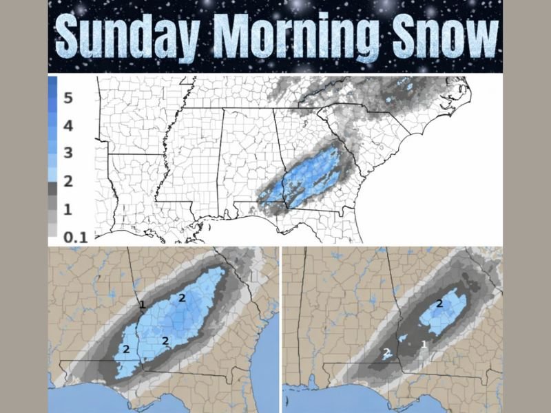
Model guidance shows the system strengthening after midnight, especially across central and southern Alabama, before tracking eastward into Georgia by early Sunday morning.
Timing Favors Brief but Heavy Snowfall Rates
Forecasters emphasize that timing is critical with this event. Snow is expected to begin after midnight farther west, then reach Georgia near daybreak and into mid-morning. During this window, snowfall rates could briefly become moderate to heavy, producing large flakes and sharply reduced visibility.
Even though snowfall may look intense, surface temperatures hovering near or just above freezing will limit how much snow sticks.
Where the Heaviest Snow Is Most Likely
The most favored area for measurable snowfall currently stretches from south-central Alabama into parts of central and southern Georgia. In this corridor, localized accumulations of 1 to 2 inches are possible, mainly on grassy areas, rooftops, and elevated surfaces.
Farther south, meteorologists say snowflakes may even reach the Florida Panhandle and Gulf Coast, an exceptionally rare sight. However, accumulation in Florida is unlikely, as temperatures will remain too warm at the surface.
Why Accumulation Will Remain Limited
Despite the impressive appearance of snowfall, ground temperatures remain above freezing, especially after sunrise. As a result, most roads are expected to stay wet rather than snow-covered, though brief slick spots cannot be ruled out, particularly on bridges and overpasses early Sunday morning.
This type of setup often produces eye-catching snowfall with minimal long-term impacts, a classic hallmark of southern winter events.
High Uncertainty Due to Narrow Snow Band
Because the snow band is expected to be tight and fast-moving, small shifts in storm track could dramatically change who sees snow and who does not. A shift of just 20 to 30 miles could mean the difference between steady snowfall and nothing at all.
Forecasters stress that confidence is high in snowflakes falling, but lower when it comes to exact totals and placement.
What Residents Should Expect Sunday Morning
While widespread travel disruptions are not anticipated, drivers should use caution during the early morning hours, when visibility may drop suddenly during heavier snow bursts. Residents across Alabama, Georgia, and northern Florida are encouraged to look outside early Sunday morning, as snow chances diminish quickly once daytime warming begins.
Have you ever seen snow where you live in the Deep South? Share your observations and experiences as this rare winter moment unfolds, and stay updated with continued coverage from SaludaStandard-Sentinel.com.