Alabama Forecast Signals Widespread Soaking Rains Next Weekend as Models Show High Uncertainty on Heaviest Totals
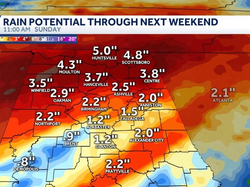
ALABAMA — Forecast models continue to show a widespread rain event setting up across Alabama on Friday and Saturday, but meteorologists stress that the exact placement of the heaviest rainfall remains uncertain due to normal model margin of error.
The difference between heavier and lighter rainfall zones could come down to a shift of about 150 miles, which is well within the expected range for forecasts made several days in advance.
Forecast Models Show a Broad Rain Band, Not a Precise Stripe
Current guidance suggests a solid stripe of rain will develop somewhere across the state, but forecasters caution that models can present realistic-looking scenarios that are still subject to adjustment.
While confidence is high that Alabama will see a meaningful rain event, pinpointing exactly where the highest totals will land is not yet possible.
Some projections place heavier rainfall closer to the Tennessee Valley, while others shift the axis south toward central Alabama, including areas near Prattville and Birmingham.
Rain Totals Vary Widely Across the State
Rainfall estimates currently range from around 1 inch on the lower end to more than 4 inches in localized areas, depending on where the main rain band ultimately sets up.
Northern Alabama locations have been shown in some model runs receiving higher totals, while central and southern portions of the state see more moderate accumulations. These totals may continue to adjust as newer data comes in.
Severe Weather and Major Flooding Not Expected
At this time, forecasters do not expect severe weather associated with this system. Thunderstorms may occur, but the setup does not favor organized severe storms.
Major flooding is also considered unlikely based on current rainfall intensity and duration. Rain is expected to fall steadily rather than in short, extreme bursts.
A Beneficial Soaking for Alabama
The biggest takeaway from the forecast is that this system should bring a good soaking rain, which is beneficial for groundwater recharge heading into the warmer months.
This type of rainfall helps replenish soil moisture and supports water resources ahead of the drier and hotter conditions typically seen later in the year.
What to Watch Going Forward
Forecasters will continue monitoring future model runs to refine rainfall placement and totals. Residents should remain aware that small forecast shifts can still change local impacts, even if the overall message stays the same.
At this point, the focus remains on beneficial rainfall rather than hazardous weather.
Have you seen rainfall totals changing in your area? Share your local conditions and stay updated with weather coverage at SaludaStandard-Sentinel.com, where we track developing forecasts across the Southeast.
By Savannah Greene | Category: Weather
If you want next, I can:
- Rewrite this with a county-by-county Alabama focus
- Convert it into a public safety rain explainer
- Create a follow-up article once models tighten
- Adapt it for Georgia or Tennessee using the same system
Just say the word.