Alabama Braces for Monday Afternoon Storms With Heavy Rain, 50+ MPH Wind Gusts and Intense Lightning Risk
ALABAMA — A wave of spring thunderstorms is expected to move across Alabama Monday afternoon, bringing periods of heavy rain, strong wind gusts, and intense lightning as the system tracks through the region.
Forecasters say the storms could develop quickly during the afternoon hours and continue into the evening as a band of rain and thunderstorms spreads across much of the state. While the overall severe weather risk currently appears on the lower end, meteorologists warn that individual storms may still produce brief but strong impacts, particularly with gusty winds and downpours.
Heavy Rain Bands Expected to Cross Alabama
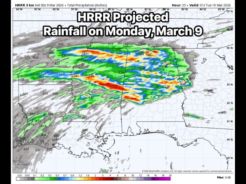
Weather model projections show a broad swath of rain pushing across Alabama during the day Monday. The system is expected to bring periods of moderate to heavy rainfall, with some areas potentially seeing heavier bursts of precipitation as thunderstorms intensify.
Localized rainfall totals may vary depending on where stronger storm cells develop, but widespread showers are likely across much of the state. The rain will move from west to east through Alabama, gradually spreading across central and eastern portions of the state by the evening hours.
Wind Gusts and Lightning Possible With Stronger Storms
Although the severe threat remains limited overall, forecasters say some storms may still produce wind gusts exceeding 50 miles per hour. These gusts could bring isolated tree damage or brief power outages, particularly if stronger thunderstorm cells develop within the broader rain band.
Lightning is also expected to accompany the storms, with meteorologists warning that frequent lightning strikes may occur in stronger thunderstorms. Residents are encouraged to move indoors if thunder is heard and avoid outdoor activities during periods of lightning.
Severe Risk Low — But Not Zero
Meteorologists emphasize that even when severe weather risk levels are relatively low, a single storm can still produce damaging conditions. That means isolated areas could experience stronger storms even if the majority of the state sees only moderate rainfall and occasional thunder. Because of this, forecasters say they will continue monitoring storm development closely throughout the day Monday.
Residents Encouraged to Monitor Weather Updates
With storms expected to move through during the afternoon and evening hours, residents across Alabama should stay aware of weather conditions and be prepared for changing forecasts.
Drivers should also be cautious on roads during periods of heavy rain, as visibility may drop quickly when stronger storms pass through. Officials recommend keeping weather alerts enabled and checking updates throughout the day as the system approaches. Stay with SaludaStandard-Sentinel.com for continuing updates as meteorologists track developing spring storms across Alabama and the Southeast.