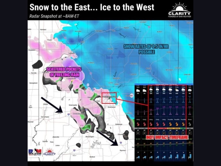
Above-Normal Temperatures to Dominate Most of the U.S. Next Week as Late-Winter Warm Pattern Expands East of the Rockies
UNITED STATES — A broad warm-up is expected to take hold across much of the country next week, with new 6–10 day outlook data showing above-normal temperatures dominating areas east of the Rockies.
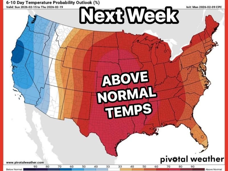
The temperature probability outlook, valid from February 15 through February 19, highlights a strong signal for warmer-than-average conditions across the central United States, Midwest, Great Lakes, South, and much of the East Coast. Forecasters indicate this pattern could bring afternoon highs into the 60s in several regions, particularly across parts of the South and Mid-Atlantic.
Central U.S. and Midwest See Strongest Warm Signal
The highest probabilities for above-normal temperatures are centered across the Plains and Midwest. States stretching from Texas northward through the central Plains and into the Upper Midwest are shaded in deeper red tones, signaling a stronger confidence in warmer-than-average conditions.
This suggests a sustained mild pattern rather than a brief one-day warm surge. If the outlook holds, communities in these regions could experience a noticeable break from typical mid-February chill.
East Coast Also Trending Warmer
The warm pattern extends eastward through the Ohio Valley and into much of the Northeast. While probabilities vary slightly, much of the eastern half of the country is forecast to lean warmer than climatological averages.
For many areas, especially across the Southeast and parts of the Mid-Atlantic, afternoon highs in the 60s are considered likely during portions of the week. The consistent mild trend could help limit prolonged cold snaps as the calendar moves closer to March.
Western U.S. Remains Cooler
In contrast, the western United States shows a cooler-than-normal signal. Coastal California and parts of the Pacific Northwest are shaded in blue, indicating below-normal temperature probabilities for that region.
This west-to-east contrast suggests a pattern where cooler air remains anchored near the Pacific Coast while warmer air expands across the central and eastern U.S.
Late-Winter Pattern Shifting
The broader pattern indicates a shift away from widespread arctic outbreaks, at least temporarily. While it remains winter, the absence of extreme cold during this period could help reduce strain from prolonged freezing conditions across much of the country.
As always, long-range outlooks highlight trends rather than exact daily highs. Residents are encouraged to monitor updated forecasts as the valid period approaches.
Are you ready for a stretch of milder late-winter weather? Share your thoughts and follow continuing updates at SaludaStandard-Sentinel.com.