Washington, Oregon And Idaho Faces Sharp Temperature Drop and Early Snowfall Threat as Thanksgiving Week Approaches
PACIFIC NORTHWEST — A strong blast of Arctic air is forecast to sweep across the Pacific and Inland Northwest next week, bringing a sharp temperature drop and the potential for early-season snow just as millions prepare for Thanksgiving travel.
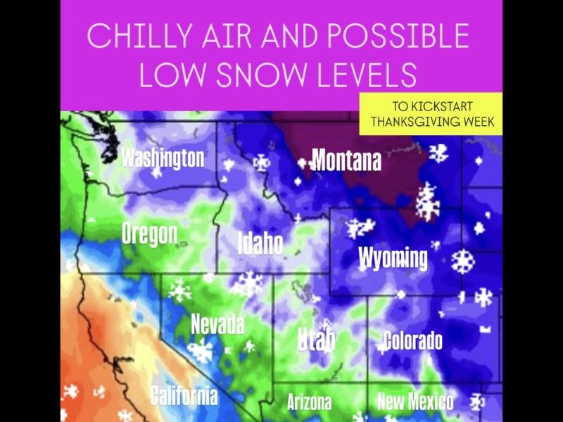
Meteorologists are tracking a developing pattern that will cause temperatures to fall well below seasonal averages across Washington, Oregon, Idaho, Montana, and Wyoming, with snow levels expected to plummet to lower elevations. The cold wave is also forecast to extend into parts of the northern and central Rockies, including regions of Utah, Colorado, and Nevada.
Thanksgiving Week Could Start with Bitter Cold and Possible Lowland Snow
Forecasters say the early winter system could set up a significant chill across the Northwest to kick off Thanksgiving week, with highs struggling to reach the 30s and 40s in some inland valleys. Nighttime temperatures could dip into the teens and 20s in higher terrain.
“It’s too early to determine whether moisture will line up with the cold air to create widespread snowfall,” forecasters explained, “but the potential exists for low snow levels and even some snow mixing into valley areas.”
The system is part of a broad jet stream dip, pulling cold air from western Canada into the U.S. A map released by meteorologists shows widespread blue and purple shading across the Northwest — a clear indicator of significant cold anomalies and possible early-season snow showers.
States Likely to Feel the Chill
The core of the coldest air is expected to center over:
- Washington and Oregon: Possible snow in higher valleys and mountain passes
- Idaho and Montana: Snowfall potential increasing, with frigid overnight lows
- Wyoming and Utah: Snow showers likely, with below-normal daytime highs
- Colorado and northern Nevada: Chilly air spreading eastward with scattered flurries
Meanwhile, parts of California and Arizona could also experience cooler-than-normal temperatures, though the main impacts are expected further north.
Travelers Urged to Stay Alert Ahead of Thanksgiving Rush
With Thanksgiving week travel about to begin, meteorologists are urging drivers and airline passengers to keep a close watch on evolving forecasts. Mountain passes in Idaho, Wyoming, and Montana could see slick conditions, while strong winds and reduced visibility may impact regional airports.
“This is shaping up to be a busy week for travelers, and cold air combined with even light snow can create big delays,” one weather service official said. “It’s not time to panic — just time to plan.”
Looking Ahead: Winter-Like Conditions May Persist
While this upcoming system may not deliver heavy snow to all areas, forecasters note that it could set the stage for a colder and stormier pattern heading into late November and early December.
“This kind of setup often signals the start of sustained winter weather in the western U.S.,” meteorologists explained. “Even if next week’s snow doesn’t reach the valleys, the colder air will certainly be felt.”
Residents are advised to prepare vehicles, winterize homes, and monitor local forecasts for updates as the cold front moves in.
Stay updated on Thanksgiving week weather developments and travel conditions at SaludaStandard-Sentinel.com.
By Savannah Greene | Category: Weather