Central Illinois Could See Repeated Storms and Early Snow as Meteorologists Warn of Active Late-November Weather Pattern
ILLINOIS — A more active and storm-filled weather pattern is expected to settle across the Midwest during the second half of November, according to Meteorologist Chris Yates, who shared new outlook maps and details on Friday evening.
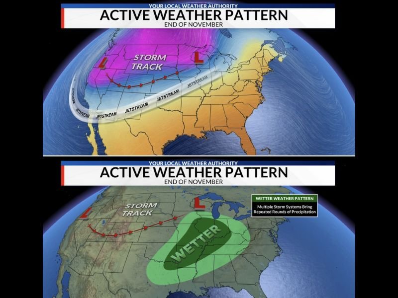
Yates explained that a large-scale trough will develop across the western United States, while an upper-level ridge will remain over the East Coast. This setup will send multiple storm systems moving across the country in the coming weeks, increasing the likelihood of rainfall and even early snow for parts of Illinois.
“Several storm systems will kick out from this trough over the next few weeks bringing multiple opportunities for rain, and maybe snow,” Yates wrote.
Central Illinois in the ‘Battle Zone’ Between Warm and Cold Air
The forecast places Central Illinois near the Baroclinic Zone — the atmospheric boundary where warm and cold air masses meet. This zone often becomes a battleground for shifting weather conditions, including severe rain, thunderstorms, or early-season snow events.
Depending on how this zone moves before and after each storm, Illinois could see a mix of heavy rain, windy conditions, and bursts of cold air toward the end of the month.
“Either way, above-average precipitation is favored across the region for the second half of the month,” Yates added.
Multiple Storm Tracks Could Bring Wet and Unstable Weather
Weather models shared by Yates show a storm track running from the Pacific Northwest through the central U.S. before turning northeast toward the Great Lakes. This pattern funnels wet, unstable air into the Midwest — including Illinois, Indiana, and parts of Missouri — marking a clear shift from the drier pattern seen earlier in November.
The graphics highlight that by late November, much of Illinois and the lower Midwest will fall under a “wetter” zone, with frequent rounds of precipitation.
Cooler Temperatures Expected by Early December
While the end of November may be dominated by storm systems, cooler air is expected to take over once the western trough shifts east.
“Once the west coast trough shifts east, it would leave us with some cooler temperatures as we kick off the month of December,” Yates said.
That transition could bring the first notable cold spell of the season, setting up possible early snow flurries or mixed precipitation for parts of Central and Northern Illinois heading into December.
What Residents Should Expect
Meteorologists are advising residents to prepare for:
- More frequent rain events in the final two weeks of November.
- The possibility of minor snow accumulations in some parts of the state.
- Cooler temperatures developing by early December.
The National Weather Service has also noted that late-fall storm patterns can change rapidly, meaning local forecasts will likely be updated frequently over the next two weeks.
Residents are encouraged to stay tuned to local weather updates as multiple systems move through the region.
Stay informed with SaludaStandard-Sentinel.com for continued coverage of late-fall and early-winter weather patterns across Illinois and the Midwest.