Chicago Braces for Up to 18 Inches of Lake-Effect Snow as Powerful System Moves in Sunday Night
CHICAGO, Ill. — A powerful lake-effect snowstorm is expected to hit the Chicago area Sunday night into Monday, with meteorologists warning that up to 18 inches of snow could fall in some spots south of Lake Michigan.
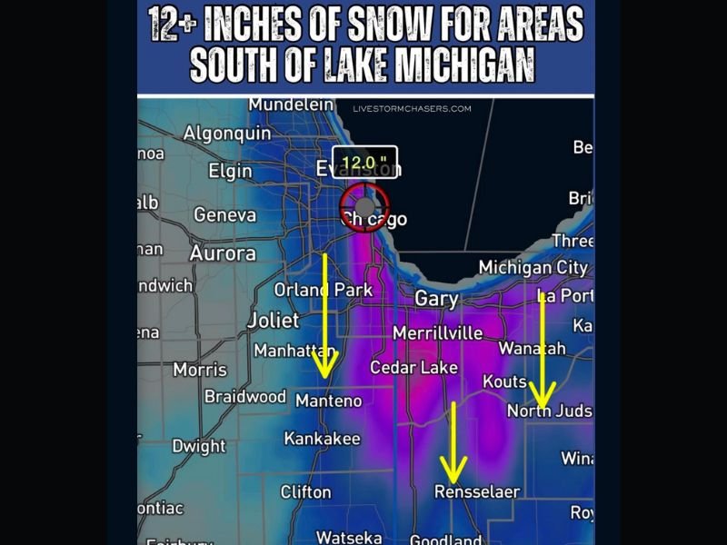
High-resolution forecast models show a major snow event developing late Sunday, with heavy, wind-driven snow expected to continue through early Monday morning. The most intense snowbands are expected to form over southern and eastern sections of the metro area, where conditions are ideal for prolonged lake-effect activity.
Forecasters Warn of Significant Accumulation
Meteorologists tracking the system said some parts of Cook, Will, and Lake counties could see more than a foot of snow, while surrounding areas including Gary, Merrillville, Kankakee, and Rensselaer may also experience 12 to 18 inches of accumulation where the heaviest bands set up.
“This could be a major snow event for the Chicago region,” forecasters noted, warning of potential whiteout conditions during periods of strongest snowfall. “If these snowbands stall, accumulation totals could exceed a foot in multiple locations.”
Travel and Commute Concerns
Officials are urging residents to prepare for hazardous travel conditions, particularly during Monday morning’s commute. Visibility may drop quickly during bursts of snow, and roads are expected to become slick and snow-covered overnight.
Wind gusts along the lakeshore could make driving even more dangerous, with drifting snow expected to affect open areas and interstates, including I-90, I-94, and I-80.
Snow removal crews are preparing for round-the-clock operations as the storm intensifies, though meteorologists say the exact placement of snowbands will determine which communities see the heaviest impact.
Looking Ahead
By Monday afternoon, snow is expected to taper off gradually, leaving behind a deep blanket of snow across southern Cook County and extending into northwest Indiana. Temperatures will remain below freezing into midweek, meaning much of the accumulation will linger.
Residents are advised to monitor updated forecasts through local meteorologists and the National Weather Service in Chicago, as small track changes could affect totals dramatically.
Stay tuned to SaludaStandard-Sentinel.com for continuing updates, road conditions, and safety alerts as the lake-effect storm unfolds.