Damaging Winds Large Hail and Tornadoes All Possible Sunday Evening From St Louis to Louisville as Severe Storm Risk Shifts Southward
ST. LOUIS, MO — Severe storms are expected to develop Sunday afternoon and evening across a broad corridor stretching from St. Louis to Louisville, with damaging winds, large hail, and tornadoes all possible as forecasters note slight southerly shifts were made to the risk area with the morning update.
Highest Threat Centered Over Missouri and Southern Illinois
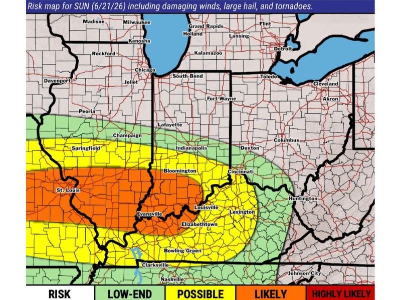
The updated risk map highlights a Likely category for severe storms covering St. Louis, Evansville, and the surrounding region, representing the highest confidence area for damaging winds, large hail, and tornadoes Sunday afternoon and evening. This zone extends across southern Illinois and into southwestern Indiana, capturing communities most likely to see significant severe weather impacts.
A broader Possible category surrounds this core threat area, extending from Springfield and Bloomington eastward through Louisville, Lexington, and Bowling Green, indicating elevated but somewhat lower confidence for severe weather across this wider swath of the Ohio and Mississippi Valleys.
Low-End Risk Extends Into Indiana and Ohio
A Low-End risk category stretches from around Indianapolis and Cincinnati eastward toward Columbus and Dayton, suggesting that while severe weather remains possible across these areas, both the coverage and intensity are expected to be more limited compared to the higher-risk zone farther west and south.
This gradient reflects how the overall severe weather threat diminishes moving eastward away from the primary corridor, though residents across the broader Ohio Valley region should still remain weather aware given the potential for damaging winds and hail.
Afternoon and Evening Timing Expected
Forecasters indicated that all three severe weather hazards, damaging winds, large hail, and tornadoes, will be possible specifically during the afternoon and evening hours Sunday. This timing places the greatest risk window during a period when outdoor activities and evening commutes could be directly affected across the highlighted risk corridor.
Risk Area Shifted Slightly South With Latest Update
The latest forecast update included a slight southerly shift in the overall risk placement compared to previous outlooks, reflecting refined data on the expected track and timing of the developing severe weather setup as it moves through the Ohio and Mississippi Valley regions Sunday.
For continuing coverage of severe weather events and storm forecasts across the United States, visit SaludaStandard-Sentinel.com.