Deeper Tropical Thunderstorms Stream Into Southeast Texas Before Dawn With Localized and Flash Flooding Possible From Houston to Corpus Christi
HOUSTON, TX — Deeper tropical thunderstorms streamed into southeast Texas before 6 AM, bringing the threat of localized flooding and even flash flooding to a broad stretch of the coastline extending from the Houston metro area southward toward Corpus Christi, as intense rain bands moved through the region early in the morning.
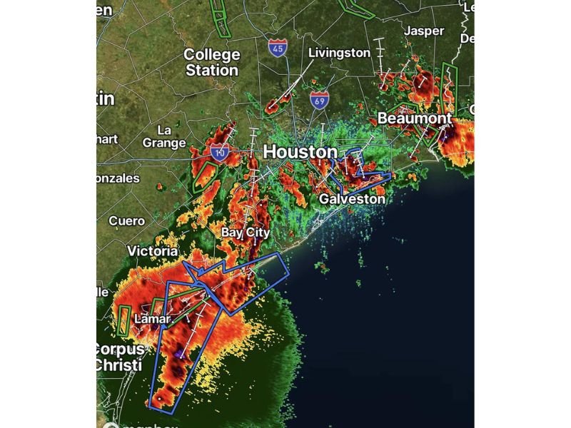
Intense Rain Bands Stretch Along the Coast
Radar imagery showed an extensive line of heavy tropical thunderstorms stretching from south of Corpus Christi northward through Victoria, Bay City, and into the Houston metro area. The most intense rainfall cores, indicated by dark red, purple, and white returns, were concentrated near Victoria and Lamar, suggesting extremely heavy rainfall rates in that portion of the coastline.
The storm complex continued extending northeastward through Galveston and toward Beaumont, with additional pockets of intense rainfall visible near the Texas-Louisiana border, indicating the tropical moisture plume spanned a wide stretch of the Gulf Coast region.
Houston Metro Sees Direct Impacts Before Sunrise
The Houston metro area was experiencing direct impacts from the heavier rain bands as the system moved through before dawn, with embedded storm cores tracking across the city and toward Galveston Bay. This timing placed the heaviest rainfall directly over a heavily populated urban corridor known for rapid street flooding during intense rain events.
Livingston and areas along the Interstate 69 corridor north of Houston also saw isolated stronger cells, while College Station and areas farther inland remained largely outside the most intense rainfall axis at the time of the radar image.
Flash Flooding Threat Spans Multiple Counties
Given the tropical nature and intensity of the rainfall, forecasters warned that some localized flooding and even flash flooding were possible across the affected corridor. Areas with the heaviest and most prolonged rainfall, particularly near Victoria, Bay City, and the Houston-Galveston corridor, carried the greatest risk for rapid water rises on roadways.
Storms Expected to Continue Through the Morning
With the tropical thunderstorm complex continuing to stream into southeast Texas before sunrise, residents across the affected coastal counties were urged to monitor conditions closely as the system continued tracking through the region during the early morning hours.
For continuing coverage of flooding threats and severe weather impacts across the United States, visit SaludaStandard-Sentinel.com.