Storms Converge From Three Directions Friday Night Surrounding Picayune as Heavy Lightning and Rain Move Through Southeast Louisiana and South Mississippi
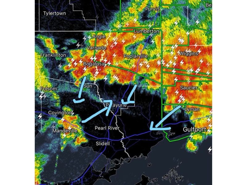
PICAYUNE, MS — Thunderstorms converging from multiple directions surrounded the Pearl River region Friday night, with radar showing intense storm activity approaching from the west, east, and north simultaneously as of 10:15 PM, creating a multi-pronged severe weather setup across southeast Louisiana and South Mississippi communities.
Storms Approach From Multiple Directions at Once
Radar imagery showed thunderstorms bearing down on the Picayune and Pearl River area from three separate directions, an unusual convergence pattern that left the community essentially surrounded by active storm cells. Heavy rain and frequent lightning were visible across Bogalusa, Varnado, and Angie to the northwest, with intense red and orange radar returns indicating very heavy rainfall rates in that corridor.
To the north and northeast, storms stretched across Poplarville, Lumberton, and Purvis, while a separate area of strong storms was tracking in from the east near Wiggins, Saucier, and Lyman, converging toward the Gulfport area.
Frequent Lightning Accompanies Heavy Rainfall
Lightning strike indicators were widespread across nearly the entire radar image, reflecting an extremely active and electrically charged storm complex. The most intense rainfall, indicated by red and embedded darker cores, was concentrated across the Bogalusa-to-Lumberton corridor, suggesting the heaviest downpours and most frequent lightning were occurring along the northern tier of the affected area.
Franklinton and Tylertown, positioned along the western edge of the radar image, also showed scattered storm activity, indicating the broader system extended well beyond the immediate Picayune area.
Southern Communities See Activity as Well
Storms were also active to the south and southwest, with Covington and Mandeville reporting scattered to numerous thunderstorm cells producing lightning and locally heavy rain. Slidell, situated between the converging systems, was positioned to see impacts as the various storm clusters continued to evolve through the night.
Multiple Storm Clusters Expected to Persist
With storm cells approaching from several directions simultaneously, residents across the region were facing an extended period of active weather Friday night, as the converging systems showed little sign of immediate weakening based on the radar presentation at the time of the update.
For continuing coverage of severe weather events and storm tracking across the United States, visit SaludaStandard-Sentinel.com.